Waterway information

Kind:
Inland
Driving areas:
🌊 Atlantic Ocean🇫🇷 France
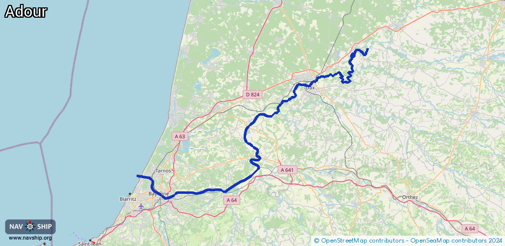
Length:
97.1 km¹
¹River kilometers or bank length recorded in NavShip, including river arms and harbor entrances.
Availability:
Completely recorded
Recent Update: 08.05.2023²
² This date indicates when an adjustment last took place in the course of the body of water
Recorded:
Locks: 0
Harbours / marinas: 4
Bridges: 0
Berths: 4
Slipways: 1
Fuelstations: 0
Route:
Please wait, loading route graphic...
Request waterway overview map with symbol legend here (Link).
Information about data associated with this body of water (9 available):
Data by OpenSeaMap (c) OSM contributors, www.openseamap.org
| # | Kind | Coordinates | Name | Information |
|---|---|---|---|---|
| 1 | Marina | 43.52254,-1.49047 | 2023-11-02T00:01:46Z | Port de la Cale |
| 2 | Marina | 43.52244,-1.49665 | 2023-11-05T03:31:50Z | Port Bayonne Anglet +33 8 10 10 01 35 https://www.port-adhoc.com/les-ports/port-a-sec-bayonne/ |
| 3 | Marina | 43.52567,-1.5066 | 2025-01-23T15:15:47Z | Port de Plaisance du Brise-Lames [email protected] +33 5 59 63 83 45 https://www.communaute-paysbasque.fr/ |
| 4 | Marina | 43.52668,-1.51373 | 2023-12-19T08:08:00Z | Capitainerie du Port de Bayonne [email protected] +33 5 59 63 05 45 |
| 5 | Slipway | 43.52545,-1.50394 | small_craft_facility | 2013-05-12T15:20:36Z by car |
| 6 | Berth | 43.51158,-1.49599 | 2024-12-30T13:56:31Z | Poste Armand Gommes |
| 7 | Berth | 43.51313,-1.49455 | 2024-03-07T08:41:43Z | Poste Edouard Castel (EC) Berth Edouard Castel |
| 8 | Berth | 43.51454,-1.49357 | 2024-03-07T08:41:43Z | Poste Edouard Castel D?? Aval |
| 9 | Berth | 43.51738,-1.48932 | 2024-03-05T09:26:40Z | Poste Saint-Gobain Poste d'Attente sans exploitation commerciale mais un accès routier à proximité + parking de fortune. |