Waterway information

Kind:
Inland
Driving areas:
🇬🇧 United Kingdom
Length:
91.8 km¹
¹River kilometers or bank length recorded in NavShip, including river arms and harbor entrances.
Availability:
Completely recorded
Recent Update: 17.02.2019²
² This date indicates when an adjustment last took place in the course of the body of water
Recorded:
Locks: 0
Harbours / marinas: 7
Bridges: 0
Berths: 0
Slipways: 1
Fuelstations: 0
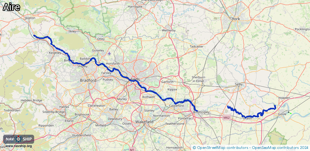
Route:
Please wait, loading route graphic...
Request waterway overview map with symbol legend here (Link).
Information about data associated with this body of water (8 available):
Data by OpenSeaMap (c) OSM contributors, www.openseamap.org
| # | Kind | Coordinates | Name | Information |
|---|---|---|---|---|
| 1 | Marina | 53.74749,-1.42465 | 2023-06-06T21:15:59Z | Lemonroyd Marina |
| 2 | Marina | 53.76128,-1.44873 | 2019-08-05T06:57:36Z | |
| 3 | Marina | 53.77634,-1.51271 | 2019-08-05T06:57:36Z | |
| 4 | Marina | 53.7923,-1.53365 | 2019-08-05T06:57:36Z | Leeds Dock |
| 5 | Marina | 53.7932,-1.55016 | 2019-08-05T06:57:36Z | |
| 6 | Marina | 53.80334,-1.5897 | 2019-08-05T06:57:36Z | Aire Valley Marina |
| 7 | Marina | 53.82463,-1.63845 | 2019-08-06T16:26:13Z | Fallwood Marina |
| 8 | Slipway | 53.82376,-1.63879 | small_craft_facility | 2019-08-06T16:26:13Z |