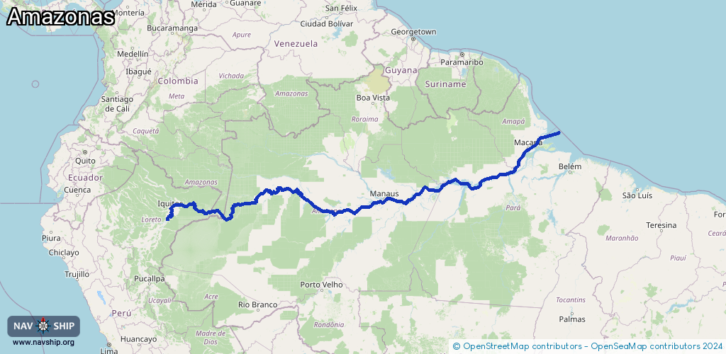
Waterway information

Kind:
Inland
Driving areas:
🌊 Atlantic Ocean🇧🇷 Brazil🇨🇴 Colombia🇵🇪 Peru
Length:
3895.5 km¹, 6400 km official total length
¹River kilometers or bank length recorded in NavShip, including river arms and harbor entrances.
Availability:
Completely recorded
Recent Update: 19.08.2025²
² This date indicates when an adjustment last took place in the course of the body of water
Recorded:
Locks: 0
Harbours / marinas: 28
Bridges: 0
Berths: 2
Slipways: 0
Fuelstations: 0
Useful information:
Course: Peru → Colombia → Brazil
Flows into: Atlantic Ocean
The Amazon is the world's largest river in terms of volume and the heart of the South American rainforest. It flows through dense primeval forests, supplies millions of people and is home to an unrivalled diversity of species.
Special features:
Around 20% of the world's fresh water flows through the Amazon.
Over 1,100 tributaries, including the Rio Negro and Madeira.
The river plays a central role in the global climate system.
The Amazon rainforest is often referred to as the “green lungs of the Earth.”
Route:
Please wait, loading route graphic...
Request waterway overview map with symbol legend here (Link).
Information about data associated with this body of water (30 available):
Data by OpenSeaMap (c) OSM contributors, www.openseamap.org
| # | Kind | Coordinates | Name | Information |
|---|
| 1 | Marina | -4.04514,-69.5282 | 2015-01-20T01:35:59Z | Belém do Solimões |
| 2 | Marina | -3.45944,-68.94197 | 2019-09-13T17:54:19Z | São Paulo de Olivença |
| 3 | Marina | -3.10855,-67.94407 | 2015-07-05T18:37:33Z | Santo Antônio do Iça |
| 4 | Marina | -2.8633,-67.771 | 2025-03-01T21:39:01Z | Tonantins |
| 5 | Marina | -2.15389,-56.09672 | 2014-06-22T02:10:53Z | Jurutí |
| 6 | Marina | -2.49598,-66.06934 | 2015-07-01T21:59:00Z | Fonte Boa |
| 7 | Marina | -3.58272,-61.40363 | 2015-07-05T18:37:44Z | Anamã |
| 8 | Marina | -3.21058,-64.80718 | 2015-07-05T23:32:56Z | Alvarães |
| 9 | Marina | -3.08225,-59.86043 | 2020-07-03T05:46:10Z | Porto Carinhoso |
| 10 | Marina | -4.21685,-69.94942 | 2025-09-02T08:26:21Z | Letícia |
| 11 | Marina | -4.22221,-69.9588 | 2024-09-08T11:16:10Z | Puerto Santa Rosa |
| 12 | Marina | -4.23099,-69.94554 | 2015-07-02T13:17:24Z | Tabatinga |
| 13 | Marina | -4.23468,-69.94454 | 2024-11-19T12:39:08Z | Terminal hidroviario de Tabatinga |
| 14 | Marina | -3.84353,-62.06493 | 2015-07-05T18:39:29Z | Codajás |
| 15 | Marina | -0.05746,-51.18009 | 2019-01-28T15:02:41Z | Porto Santana |
| 16 | Marina | -0.05748,-51.17896 | 2025-11-05T11:30:54Z | Porto do Grego |
| 17 | Marina | -0.05747,-51.17797 | 2025-11-05T11:30:54Z | Porto Souzamar |
| 18 | Marina | -0.06169,-51.16675 | 2014-06-22T02:08:44Z | |
| 19 | Marina | -0.06108,-51.15951 | 2014-06-22T02:08:44Z | |
| 20 | Marina | -3.304,-60.6214 | 2015-07-05T18:37:33Z | Manacapuru |
| 21 | Marina | -2.71645,-57.70613 | 2014-06-22T02:10:56Z | Porto Equador |
| 22 | Marina | -2.62239,-56.73438 | 2023-09-10T20:58:04Z | Porto de Parintins
Desafio 2 - abastecimento e transporte da ilha de Parintins |
| 23 | Marina | -3.73988,-73.24081 | 2024-09-08T11:11:43Z | Embarcadero el Huequito |
| 24 | Marina | -3.72158,-73.2379 | 2015-07-02T11:50:58Z | Iquitos |
| 25 | Marina | -2.01013,-54.07019 | 2015-07-02T18:54:06Z | Monte Alegre |
| 26 | Marina | -3.14749,-58.44901 | 2020-05-15T07:08:53Z | Itacoatiara |
| 27 | Marina | -3.10211,-58.31665 | 2014-06-22T02:10:57Z | Porto Isabel |
| 28 | Marina | -1.04319,-51.70134 | 2014-06-21T02:32:36Z | Porto Campina |
| 29 | Berth | -0.06171,-51.10975 | 2013-04-28T03:20:58Z | |
| 30 | Berth | 0.01346,-50.99969 | 2013-04-28T03:20:58Z | |