Waterway information

Kind:
Inland
Driving areas:
🇺🇸 United States of America
Length:
4.2 km¹
¹River kilometers or bank length recorded in NavShip, including river arms and harbor entrances.
Availability:
Completely recorded
Recent Update: 24.11.2023²
² This date indicates when an adjustment last took place in the course of the body of water
Recorded:
Locks: 0
Harbours / marinas: 4
Bridges: 0
Berths: 0
Slipways: 1
Fuelstations: 0
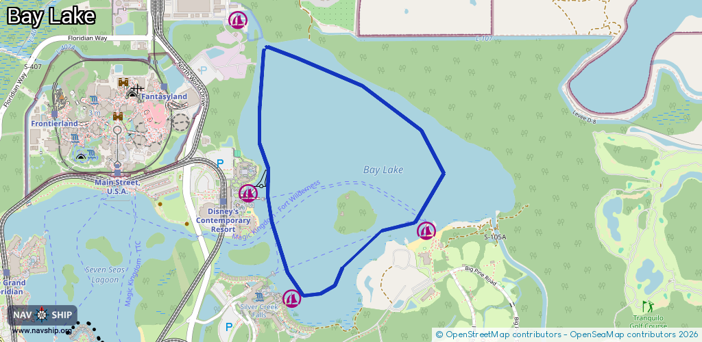
Route:
Please wait, loading route graphic...
Request waterway overview map with symbol legend here (Link).
Information about data associated with this body of water (5 available):
Data by OpenSeaMap (c) OSM contributors, www.openseamap.org
| # | Kind | Coordinates | Name | Information |
|---|---|---|---|---|
| 1 | Marina | 28.42471,-81.57376 | 2021-01-13T20:44:19Z | Walt Disney World Watercraft Marina & Drydock Disney's Private Watercraft Facilities. Not open to the Public. |
| 2 | Marina | 28.41307,-81.56177 | 2020-05-19T23:08:03Z | Fort Wilderness Marina |
| 3 | Marina | 28.40942,-81.57028 | 2020-05-19T23:08:03Z | Wilderness Lodge Marina |
| 4 | Marina | 28.41524,-81.57301 | 2020-05-19T23:08:03Z | Contemporary Marina |
| 5 | Slipway | 28.42371,-81.57308 | Unknown | 2018-04-11T04:41:17Z |