Waterway information

Kind:
Inland
Driving areas:
🇳🇱 Netherlands🌊 North Sea
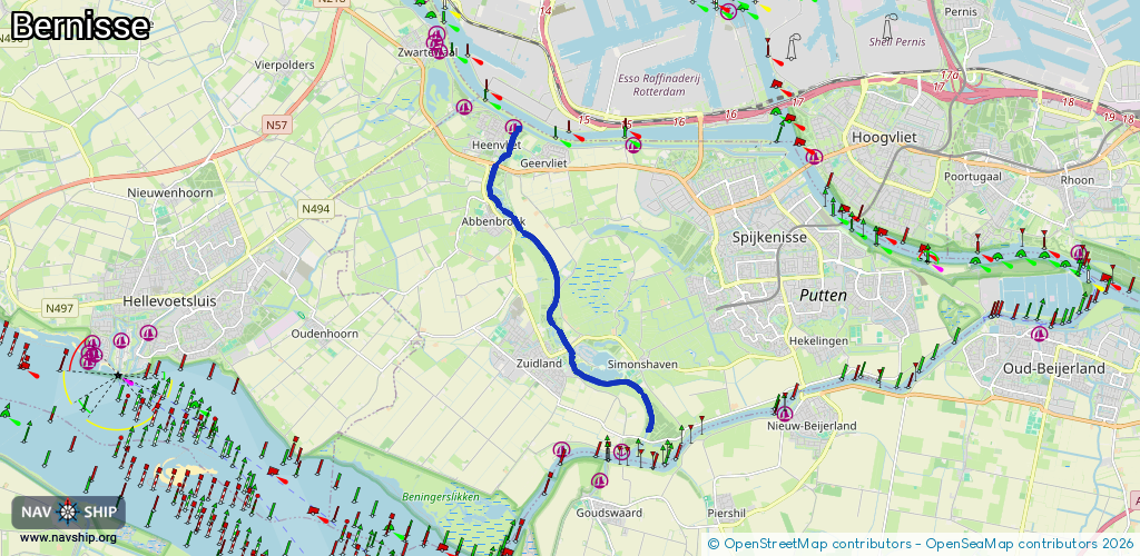
Length:
8.6 km¹
¹River kilometers or bank length recorded in NavShip, including river arms and harbor entrances.
Availability:
Completely recorded
Recent Update: 17.12.2021²
² This date indicates when an adjustment last took place in the course of the body of water
Recorded:
Locks: 0
Harbours / marinas: 1
Bridges: 5
Berths: 0
Slipways: 2
Fuelstations: 0
Route:
Please wait, loading route graphic...
Request waterway overview map with symbol legend here (Link).
Information about data associated with this body of water (8 available):
Data by OpenSeaMap (c) OSM contributors, www.openseamap.org
| # | Kind | Coordinates | Name | Information |
|---|---|---|---|---|
| 1 | Marina | 51.86696,4.24975 | 2023-08-10T23:37:39Z | WSV de kleine Bernisse |
| 2 | Bridge | 51.82492,4.26685 | Unknown | Clearance height: 2019-07-16T19:42:34Z m fixed |
| 3 | Bridge | 51.82758,4.26444 | Unknown | Clearance height: 2019-07-16T19:42:34Z m fixed |
| 4 | Bridge | 51.85276,4.24465 | Unknown | Clearance height: 2019-07-16T19:42:34Z m fixed |
| 5 | Bridge | 51.85975,4.24423 | Unknown | Clearance height: 2019-12-14T03:06:43Z m |
| 6 | Bridge | 51.85986,4.24435 | Unknown | Clearance height: 2019-12-14T03:06:43Z m fixed |
| 7 | Slipway | 51.82149,4.27316 | small_craft_facility | 2023-07-09T00:25:07Z |
| 8 | Slipway | 51.85175,4.24471 | small_craft_facility | 2023-07-14T21:30:45Z |