Waterway information

Kind:
Inland
Driving areas:
🇺🇸 United States of America
Length:
3 km¹
¹River kilometers or bank length recorded in NavShip, including river arms and harbor entrances.
Availability:
Completely recorded
Recent Update: 20.02.2024²
² This date indicates when an adjustment last took place in the course of the body of water
Recorded:
Locks: 0
Harbours / marinas: 6
Bridges: 0
Berths: 0
Slipways: 0
Fuelstations: 2
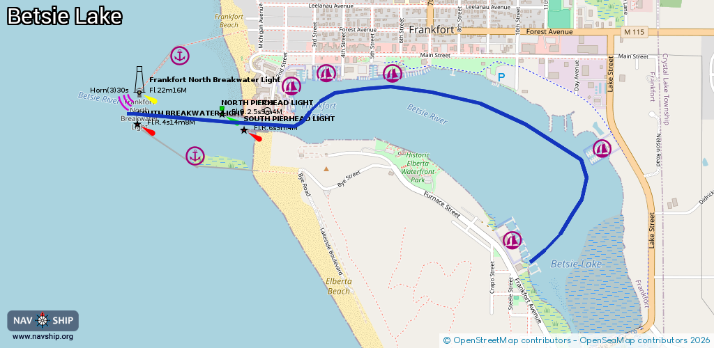
Route:
Please wait, loading route graphic...
Request waterway overview map with symbol legend here (Link).
Information about data associated with this body of water (8 available):
Data by OpenSeaMap (c) OSM contributors, www.openseamap.org
| # | Kind | Coordinates | Name | Information |
|---|---|---|---|---|
| 1 | Marina | 44.62429,-86.22918 | 2022-10-22T12:19:34Z | Betsie Bay Marina http://www.betsiebaymarina.net/ |
| 2 | Marina | 44.62853,-86.22356 | 2022-02-15T16:17:31Z | East Shore Marina https://www.eastshoremarina.com/ |
| 3 | Marina | 44.63179,-86.23662 | 2022-02-15T16:17:31Z | Frankfort Municipal Marina +1 231 352 9051 https://www.frankfortmich.com/government/marina_launch_ramp.php |
| 4 | Marina | 44.63177,-86.24083 | 2022-02-15T16:17:31Z | Jacobson Marina Resort +1 231 352 9131 https://jacobsonmarinaresort.com/ |
| 5 | Marina | 44.6311,-86.24298 | 2022-10-23T13:16:45Z | Marina at Harbor Lights http://harborlightsresort.net/the-marina-at-harbor-lights/ |
| 6 | Marina | 44.62802,-86.24841 | 2024-02-23T18:12:41Z | South Breakwater https://www.nps.gov/subjects/nationalregister/index.htm |
| 7 | Fuel station | 44.63154,-86.23598 | 2024-07-23T14:25:41Z | |
| 8 | Fuel station | 44.63141,-86.23983 | 2024-07-23T14:25:41Z |