Waterway information

Kind:
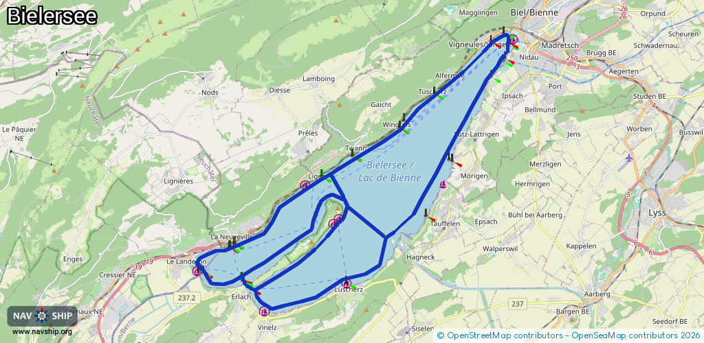
Lake
Driving areas:
🇨🇭 Switzerland
Length:
46.9 km¹
¹River kilometers or bank length recorded in NavShip, including river arms and harbor entrances.
Availability:
Completely recorded
Recent Update: 22.02.2026²
² This date indicates when an adjustment last took place in the course of the body of water
Recorded:
Locks: 0
Harbours / marinas: 5
Bridges: 0
Berths: 0
Slipways: 9
Fuelstations: 1
Route:
Please wait, loading route graphic...
Request waterway overview map with symbol legend here (Link).
Information about data associated with this body of water (15 available):
Data by OpenSeaMap (c) OSM contributors, www.openseamap.org
| # | Kind | Coordinates | Name | Information |
|---|---|---|---|---|
| 1 | Marina | 47.08129,7.12943 | 2025-12-01T17:39:17Z | Schafis |
| 2 | Marina | 47.0818,7.19825 | 2022-02-08T11:59:24Z | Gerolfingen |
| 3 | Marina | 47.03827,7.10905 | 2025-07-10T10:40:39Z | Vinelz Hafen |
| 4 | Marina | 47.06816,7.1437 | 2021-10-25T17:56:56Z | |
| 5 | Marina | 47.06977,7.14621 | 2021-10-25T17:56:56Z | Rattenhafen |
| 6 | Slipway | 47.06069,7.09145 | small_craft_facility | 2015-05-29T09:18:03Z |
| 7 | Slipway | 47.06857,7.11129 | small_craft_facility | 2015-05-29T09:18:03Z |
| 8 | Slipway | 47.12788,7.23331 | small_craft_facility | 2016-09-14T06:21:44Z |
| 9 | Slipway | 47.04642,7.10148 | Unknown | 2024-08-18T21:31:02Z |
| 10 | Slipway | 47.04639,7.10144 | small_craft_facility | 2024-08-18T21:31:02Z |
| 11 | Slipway | 47.04642,7.10149 | small_craft_facility | 2024-08-18T21:31:02Z |
| 12 | Slipway | 47.0465,7.1011 | Unknown | 2019-01-13T13:47:11Z |
| 13 | Slipway | 47.04648,7.10109 | small_craft_facility | 2024-08-18T21:31:02Z |
| 14 | Slipway | 47.04654,7.10113 | small_craft_facility | 2024-08-18T21:31:02Z |
| 15 | Fuel station | 47.04654,7.09874 | 2025-07-24T14:32:21Z | Tankstell 24/7 |