Waterway information

Kind:
Inland
Driving areas:
🇳🇱 Netherlands
Length:
7.1 km¹
¹River kilometers or bank length recorded in NavShip, including river arms and harbor entrances.
Availability:
Completely recorded
Recent Update: 15.05.2023²
² This date indicates when an adjustment last took place in the course of the body of water
Recorded:
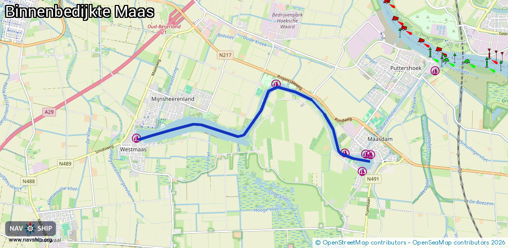
Locks: 0
Harbours / marinas: 6
Bridges: 0
Berths: 0
Slipways: 2
Fuelstations: 0
Route:
Please wait, loading route graphic...
Request waterway overview map with symbol legend here (Link).
Information about data associated with this body of water (8 available):
Data by OpenSeaMap (c) OSM contributors, www.openseamap.org
| # | Kind | Coordinates | Name | Information |
|---|---|---|---|---|
| 1 | Marina | 51.78311,4.55301 | 2021-07-20T12:46:02Z | |
| 2 | Marina | 51.78679,4.55436 | 2021-06-02T15:18:25Z | Resenburgh |
| 3 | Marina | 51.78672,4.55588 | 2022-03-18T13:00:42Z | De Hoogt |
| 4 | Marina | 51.78702,4.54693 | 2022-03-18T13:00:42Z | |
| 5 | Marina | 51.80188,4.52317 | 2021-03-04T09:40:44Z | Recreatioord Binnenmaas |
| 6 | Marina | 51.79014,4.47471 | 2021-07-20T12:46:02Z | HSVGHW | Westmaas |
| 7 | Slipway | 51.78314,4.55295 | Unknown | 2021-06-02T14:51:08Z |
| 8 | Slipway | 51.8018,4.52273 | Unknown | 2021-03-04T09:09:26Z |