Waterway information

Kind:
Lake
Driving areas:
🇸🇮 Slovenia
Length:
6.1 km¹
¹River kilometers or bank length recorded in NavShip, including river arms and harbor entrances.
Availability:
Completely recorded
Recent Update: 02.08.2023²
² This date indicates when an adjustment last took place in the course of the body of water
Recorded:
Locks: 0
Harbours / marinas: 7
Bridges: 0
Berths: 0
Slipways: 1
Fuelstations: 0
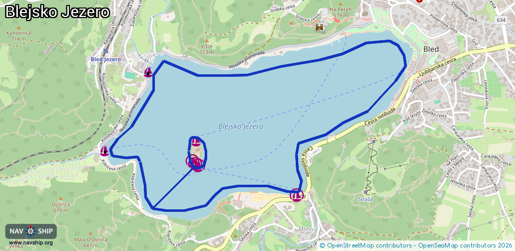
Route:
Please wait, loading route graphic...
Request waterway overview map with symbol legend here (Link).
Information about data associated with this body of water (8 available):
Data by OpenSeaMap (c) OSM contributors, www.openseamap.org
| # | Kind | Coordinates | Name | Information |
|---|---|---|---|---|
| 1 | Marina | 46.36249,14.0821 | 2023-07-30T15:19:28Z | Velika Zaka |
| 2 | Marina | 46.3671,14.08588 | 2021-08-29T18:38:09Z | Mala Zaka |
| 3 | Marina | 46.35978,14.09857 | 2023-01-13T17:34:26Z | Pristan za pletne Mlino |
| 4 | Marina | 46.36303,14.08997 | 2021-08-29T18:38:09Z | Blejski otok - Severna stran |
| 5 | Marina | 46.36152,14.09017 | 2022-07-29T09:42:46Z | Pletnarska marina |
| 6 | Marina | 46.36164,14.08994 | 2022-07-29T09:42:46Z | |
| 7 | Marina | 46.3618,14.08968 | 2022-07-29T09:42:46Z | Marina for disabled persons |
| 8 | Slipway | 46.36745,14.08594 | small_craft_facility | 2021-08-29T18:38:09Z |