Waterway information

Kind:
Inland
Driving areas:
🇧🇪 Belgium🌊 North Sea
Length:
7.9 km¹
¹River kilometers or bank length recorded in NavShip, including river arms and harbor entrances.
Availability:
Completely recorded
Recent Update: 11.02.2025²
² This date indicates when an adjustment last took place in the course of the body of water
Recorded:
Locks: 0
Harbours / marinas: 0
Bridges: 2
Berths: 6
Slipways: 0
Fuelstations: 0
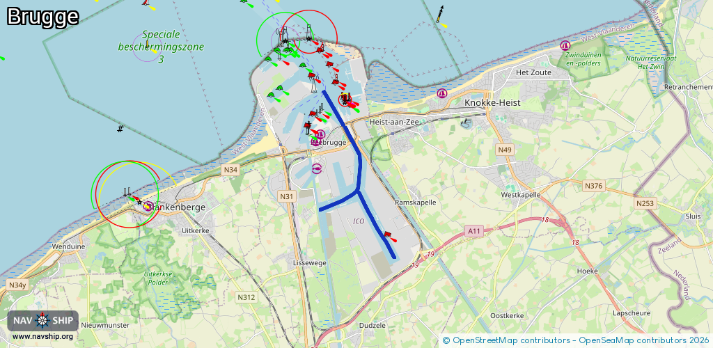
Route:
Please wait, loading route graphic...
Request waterway overview map with symbol legend here (Link).
Information about data associated with this body of water (8 available):
Data by OpenSeaMap (c) OSM contributors, www.openseamap.org
| # | Kind | Coordinates | Name | Information |
|---|---|---|---|---|
| 1 | Bridge | 51.33137,3.21945 | 57 | Clearance height: 2017-09-02T07:45:33Z m Maximum passage width: 1.0 m Movable bridge (e.g. lifting bridge or drawbridge) bascule 24/7 |
| 2 | Bridge | 51.33657,3.2149 | 57 | Clearance height: 2017-09-06T16:13:17Z m Maximum passage width: 1.0 m Movable bridge (e.g. lifting bridge or drawbridge) bascule 24/7 |
| 3 | Berth | 51.30037,3.2324 | 2025-01-10T01:30:08Z | 513 |
| 4 | Berth | 51.30194,3.23106 | 2025-01-10T01:32:11Z | 512 |
| 5 | Berth | 51.30622,3.22763 | 2020-03-02T20:27:11Z | 510 |
| 6 | Berth | 51.30806,3.22623 | 2020-03-02T20:27:11Z | 509 |
| 7 | Berth | 51.30974,3.22477 | 2020-03-02T20:27:11Z | 508 |
| 8 | Berth | 51.31175,3.22314 | 2020-03-02T20:27:11Z | 507 |