Waterway information

Kind:
Inland
Driving areas:
🇳🇱 Netherlands🌊 North Sea
Length:
12.8 km¹
¹River kilometers or bank length recorded in NavShip, including river arms and harbor entrances.
Availability:
Completely recorded
Recent Update: 20.06.2023²
² This date indicates when an adjustment last took place in the course of the body of water
Recorded:
Locks: 1
Harbours / marinas: 0
Bridges: 5
Berths: 5
Slipways: 0
Fuelstations: 0
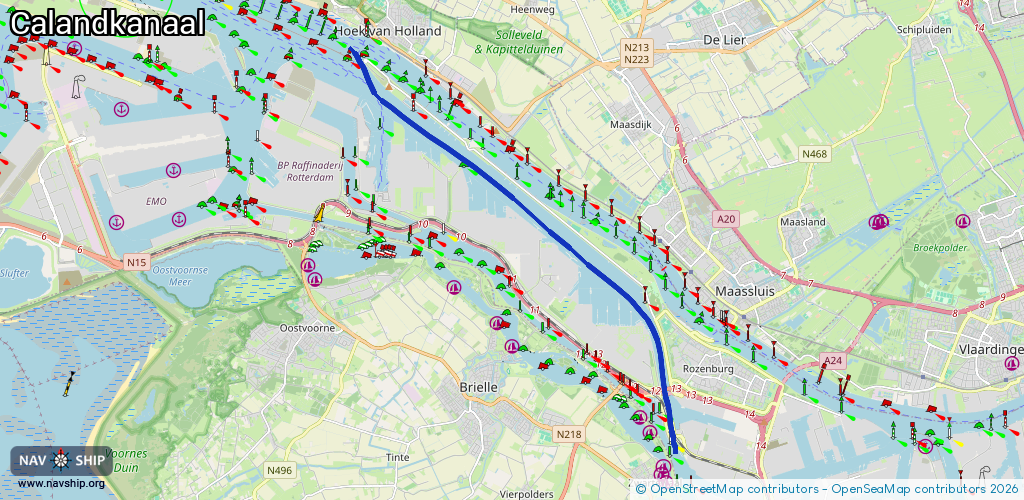
Route:
Please wait, loading route graphic...
Request waterway overview map with symbol legend here (Link).
Information about data associated with this body of water (10 available):
Data by OpenSeaMap (c) OSM contributors, www.openseamap.org
| # | Kind | Coordinates | Name | Information |
|---|---|---|---|---|
| 1 | Bridge | 51.89103,4.2293 | 24 | Clearance height: 2022-06-06T15:01:38Z m Maximum passage width: 3.6 m Movable bridge (e.g. lifting bridge or drawbridge) opening |
| 2 | Bridge | 51.89215,4.22897 | 24 | Clearance height: 2020-11-17T20:12:45Z m Maximum passage width: 14 m Movable bridge (e.g. lifting bridge or drawbridge) fixed |
| 3 | Bridge | 51.89428,4.22837 | 24 | Clearance height: 2022-06-06T15:01:39Z m Maximum passage width: 3.6 m Movable bridge (e.g. lifting bridge or drawbridge) opening |
| 4 | Bridge | 51.90131,4.22749 | 46 | Clearance height: 2022-06-06T15:01:53Z m Maximum passage width: 11.7 m Movable bridge (e.g. lifting bridge or drawbridge) lifting |
| 5 | Bridge | 51.90118,4.22621 | 80 | Clearance height: 2019-09-18T12:07:37Z m Maximum passage width: 11.7 m Movable bridge (e.g. lifting bridge or drawbridge) fixed |
| 6 | Berth | 51.96041,4.14208 | 2020-06-28T18:29:45Z | SCHEURH SMIT DUIKERS |
| 7 | Berth | 51.95742,4.12796 | 2020-06-28T18:29:45Z | ELBEH ADM ZEESTG BINNEN PALEN |
| 8 | Berth | 51.95838,4.12762 | 2024-06-30T22:31:44Z | ELBEH ADM ZEESTG BUITEN PALEN |
| 9 | Berth | 51.95987,4.12517 | 2020-06-28T18:29:45Z | ELBEH ADM ZEESTG BINNEN |
| 10 | Berth | 51.96019,4.12607 | 2024-06-30T22:31:44Z | ELBEH ADM ZEESTG BUITEN |
| 10 | Berth | 51.96019,4.12607 | 2024-06-30T22:31:44Z | ELBEH ADM ZEESTG BUITEN |