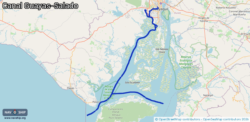
Waterway information

Kind:
Inland
Driving areas:
🇪🇨 Ecuador
Length:
137.9 km¹
¹River kilometers or bank length recorded in NavShip, including river arms and harbor entrances.
Availability:
Completely recorded
Recent Update: 10.04.2025²
² This date indicates when an adjustment last took place in the course of the body of water
Recorded:
Locks: 0
Harbours / marinas: 8
Bridges: 0
Berths: 0
Slipways: 0
Fuelstations: 0
Route:
Please wait, loading route graphic...
Request waterway overview map with symbol legend here (Link).
Information about data associated with this body of water (8 available):
Data by OpenSeaMap (c) OSM contributors, www.openseamap.org
| # | Kind | Coordinates | Name | Information |
|---|---|---|---|---|
| 1 | Marina | -2.19657,-79.9671 | 2025-11-03T17:22:07Z | Guayaquil Yacht Club - Puerto Azul |
| 2 | Marina | -2.25166,-79.92361 | 2021-12-01T21:15:13Z | INGRESO TPG INARPI 2 |
| 3 | Marina | -2.25043,-79.92505 | 2021-12-01T21:15:13Z | INGRESO NAPORTEC DOLE |
| 4 | Marina | -2.24577,-79.92745 | 2021-12-01T21:15:13Z | INGRESO TPG INARPI 1 |
| 5 | Marina | -2.1886,-79.90059 | 2022-12-13T22:01:44Z | Muelle Estero Salado |
| 6 | Marina | -2.18491,-79.89909 | 2020-09-27T17:25:57Z | Muelle Escuela de Canotaje Estero Salado |
| 7 | Marina | -2.28329,-79.90479 | 2018-02-07T20:37:29Z | Puerto Marítimo de Guayaquil http://www.puertodeguayaquil.com |
| 8 | Marina | -2.28164,-79.90828 | 2016-11-17T16:47:51Z | Puerto Marítimo de Guayaquil http://www.puertodeguayaquil.com |