Waterway information

Kind:
Inland
Driving areas:
🌊 Sea Mediterranean🇪🇸 Spain
Length:
20.1 km¹
¹River kilometers or bank length recorded in NavShip, including river arms and harbor entrances.
Availability:
Completely recorded
Recent Update: 20.06.2023²
² This date indicates when an adjustment last took place in the course of the body of water
Recorded:
Locks: 0
Harbours / marinas: 1
Bridges: 18
Berths: 0
Slipways: 1
Fuelstations: 1
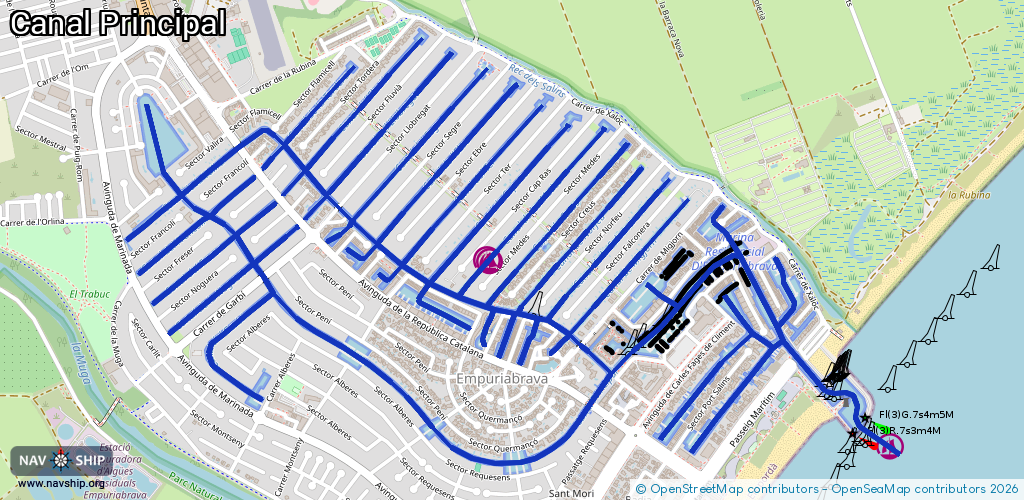
Route:
Please wait, loading route graphic...
Request waterway overview map with symbol legend here (Link).
Information about data associated with this body of water (21 available):
Data by OpenSeaMap (c) OSM contributors, www.openseamap.org
| # | Kind | Coordinates | Name | Information |
|---|---|---|---|---|
| 1 | Marina | 42.24482,3.13732 | 2022-04-20T11:19:21Z | Marina empuriabrava |
| 2 | Bridge | 42.25113,3.12367 | Unknown | Clearance height: 2026-02-22T10:56:52Z m fixed |
| 3 | Bridge | 42.24998,3.12544 | Unknown | Clearance height: 2026-02-22T10:56:52Z m fixed |
| 4 | Bridge | 42.24865,3.1253 | Unknown | Clearance height: 2026-02-22T10:05:00Z m Maximum passage width: 0.5 m fixed |
| 5 | Bridge | 42.25171,3.12279 | Unknown | Clearance height: 2026-02-22T10:56:52Z m fixed |
| 6 | Bridge | 42.25434,3.10938 | Unknown | Clearance height: 2026-02-22T10:14:40Z m |
| 7 | Bridge | 42.25243,3.11364 | Unknown | Clearance height: 2026-02-22T10:13:44Z m |
| 8 | Bridge | 42.24804,3.12405 | Unknown | Clearance height: 2025-08-19T22:37:36Z m fixed |
| 9 | Bridge | 42.25056,3.12456 | Unknown | Clearance height: 2026-02-22T10:56:52Z m fixed |
| 10 | Bridge | 42.25411,3.11673 | Unknown | Clearance height: 2026-02-22T10:56:52Z m fixed |
| 11 | Bridge | 42.24847,3.12013 | Unknown | Clearance height: 2026-02-22T10:16:09Z m |
| 12 | Bridge | 42.25273,3.11885 | Unknown | Clearance height: 2026-02-22T10:56:52Z m fixed |
| 13 | Bridge | 42.25204,3.1199 | Unknown | Clearance height: 2026-02-22T10:56:52Z m fixed |
| 14 | Bridge | 42.25021,3.11043 | Unknown | Clearance height: 2026-02-22T10:13:06Z m |
| 15 | Bridge | 42.24618,3.12445 | Unknown | Clearance height: 2026-02-22T10:12:18Z m |
| 16 | Bridge | 42.25229,3.12191 | Unknown | Clearance height: 2026-02-22T10:56:52Z m fixed |
| 17 | Bridge | 42.25487,3.11557 | Unknown | Clearance height: 2026-02-22T10:56:52Z m fixed |
| 18 | Bridge | 42.25342,3.11779 | Unknown | Clearance height: 2026-02-22T10:56:52Z m fixed |
| 19 | Bridge | 42.25557,3.11452 | Unknown | Clearance height: 2026-02-22T10:56:52Z m fixed |
| 20 | Slipway | 42.24769,3.12742 | Unknown | 2012-01-26T16:02:09Z |
| 21 | Fuel station | 42.24765,3.12619 | 2024-04-30T14:08:00Z | Repsol Repsol |