Waterway information

Kind:
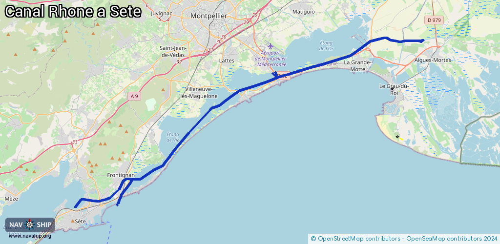
Inland
Driving areas:
🇫🇷 France🌊 Sea Mediterranean
Length:
50.8 km¹
¹River kilometers or bank length recorded in NavShip, including river arms and harbor entrances.
Availability:
Completely recorded
Recent Update: 17.04.2025²
² This date indicates when an adjustment last took place in the course of the body of water
Recorded:
Locks: 2
Harbours / marinas: 1
Bridges: 1
Berths: 0
Slipways: 0
Fuelstations: 0
Route:
Please wait, loading route graphic...
Request waterway overview map with symbol legend here (Link).
Information about data associated with this body of water (2 available):
Data by OpenSeaMap (c) OSM contributors, www.openseamap.org
| # | Kind | Coordinates | Name | Information |
|---|---|---|---|---|
| 1 | Marina | 43.55326,3.97004 | 2021-10-10T14:09:45Z | Port de Plaisance |
| 2 | Bridge | 43.517,3.88063 | 1 | Clearance height: 2026-01-15T10:03:56Z m Movable bridge (e.g. lifting bridge or drawbridge) Nov-Apr 12 Mo-Fr 11:00-17:00, Nov-Apr 12 Sa,Sun 10:00-17:00, Apr 12- Sept 21 Mo-Sun 11:00-18:00, Sept 21- Oct 31 Mo-Fr 11:00-17:30, Sept 21- Oct 31 Sa,Sun 10:00-17:30, |
| 2 | Bridge | 43.517,3.88063 | 1 | Clearance height: 2026-01-15T10:03:56Z m Movable bridge (e.g. lifting bridge or drawbridge) Nov-Apr 12 Mo-Fr 11:00-17:00, Nov-Apr 12 Sa,Sun 10:00-17:00, Apr 12- Sept 21 Mo-Sun 11:00-18:00, Sept 21- Oct 31 Mo-Fr 11:00-17:30, Sept 21- Oct 31 Sa,Sun 10:00-17:30, |
| 2 | Bridge | 43.517,3.88063 | 1 | Clearance height: 2026-01-15T10:03:56Z m Movable bridge (e.g. lifting bridge or drawbridge) Nov-Apr 12 Mo-Fr 11:00-17:00, Nov-Apr 12 Sa,Sun 10:00-17:00, Apr 12- Sept 21 Mo-Sun 11:00-18:00, Sept 21- Oct 31 Mo-Fr 11:00-17:30, Sept 21- Oct 31 Sa,Sun 10:00-17:30, |