Waterway information

Kind:
Inland
Driving areas:
🇫🇷 France
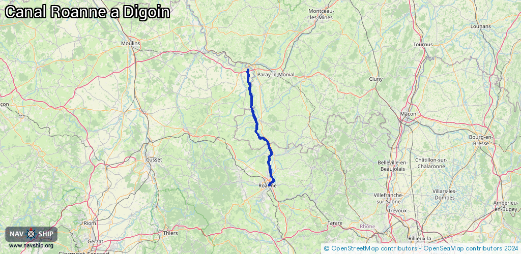
Length:
55.5 km¹
¹River kilometers or bank length recorded in NavShip, including river arms and harbor entrances.
Availability:
Completely recorded
Recent Update: 29.11.2021²
² This date indicates when an adjustment last took place in the course of the body of water
Recorded:
Locks: 10
Harbours / marinas: 2
Bridges: 0
Berths: 0
Slipways: 0
Fuelstations: 0
Route:
Please wait, loading route graphic...
Request waterway overview map with symbol legend here (Link).
Information about data associated with this body of water (12 available):
Data by OpenSeaMap (c) OSM contributors, www.openseamap.org
| # | Kind | Coordinates | Name | Information |
|---|---|---|---|---|
| 1 | Marina | 46.08689,4.08768 | 2021-08-12T11:50:29Z | Halte Nautique de Mably |
| 2 | Marina | 46.25258,4.01078 | 2020-11-11T21:32:23Z | Halte Nautique d'Artaix |
| 3 | Lock | 46.04059,4.08421 | Unknown | |
| 4 | Lock | 46.10391,4.08367 | Unknown | |
| 5 | Lock | 46.13939,4.08078 | Unknown | |
| 6 | Lock | 46.26824,4.01375 | Unknown | |
| 7 | Lock | 46.27261,4.01084 | Unknown | |
| 8 | Lock | 46.27696,4.00931 | Unknown | |
| 9 | Lock | 46.30906,3.99242 | Unknown | |
| 10 | Lock | 46.44316,3.96777 | Unknown | |
| 11 | Lock | 46.45258,3.96644 | Unknown | |
| 12 | Lock | 46.46403,3.9653 | Unknown |