Waterway information

Kind:
Inland
Driving areas:
🇫🇷 France🇩🇪 Germany
Length:
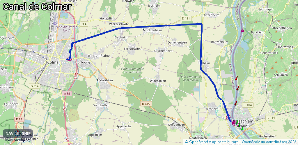
22.7 km¹
¹River kilometers or bank length recorded in NavShip, including river arms and harbor entrances.
Availability:
Completely recorded
Recent Update: 21.07.2022²
² This date indicates when an adjustment last took place in the course of the body of water
Recorded:
Locks: 4
Harbours / marinas: 2
Bridges: 6
Berths: 0
Slipways: 0
Fuelstations: 0
Route:
Please wait, loading route graphic...
Request waterway overview map with symbol legend here (Link).
Information about data associated with this body of water (12 available):
Data by OpenSeaMap (c) OSM contributors, www.openseamap.org
| # | Kind | Coordinates | Name | Information |
|---|---|---|---|---|
| 1 | Marina | 48.08011,7.37643 | 2025-08-12T12:38:55Z | Port de plaisance de Colmar |
| 2 | Marina | 48.0324,7.56385 | 2025-08-12T12:46:38Z | Port Rhénan Colmar Neuf Brisach |
| 3 | Bridge | 48.10484,7.43827 | Unknown | Clearance height: 2025-03-15T16:33:09Z m fixed |
| 4 | Bridge | 48.10552,7.45677 | Unknown | Clearance height: 2013-07-16T14:48:09Z m fixed |
| 5 | Bridge | 48.106,7.47024 | Unknown | Clearance height: 2013-07-16T14:48:09Z m fixed |
| 6 | Bridge | 48.10642,7.48242 | Unknown | Clearance height: 2013-07-16T14:48:07Z m fixed |
| 7 | Bridge | 48.10686,7.49453 | Unknown | Clearance height: 2023-07-30T17:07:20Z m fixed |
| 8 | Bridge | 48.10735,7.50835 | Unknown | Clearance height: 2013-07-16T14:48:09Z m fixed |
| 9 | Lock | 48.09432,7.38629 | Unknown | |
| 10 | Lock | 48.10522,7.4486 | Unknown | |
| 11 | Lock | 48.09564,7.53203 | Unknown | |
| 12 | Lock | 48.03375,7.56459 | Unknown |