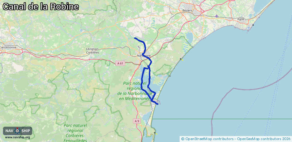
Waterway information

Kind:
Inland
Driving areas:
🇫🇷 France🌊 Sea Mediterranean
Length:
52.3 km¹
¹River kilometers or bank length recorded in NavShip, including river arms and harbor entrances.
Availability:
Completely recorded
Recent Update: 04.04.2025²
² This date indicates when an adjustment last took place in the course of the body of water
Recorded:
Locks: 1
Harbours / marinas: 4
Bridges: 0
Berths: 0
Slipways: 8
Fuelstations: 0
Route:
Please wait, loading route graphic...
Request waterway overview map with symbol legend here (Link).
Information about data associated with this body of water (13 available):
Data by OpenSeaMap (c) OSM contributors, www.openseamap.org
| # | Kind | Coordinates | Name | Information |
|---|---|---|---|---|
| 1 | Marina | 43.02299,3.04496 | 2018-09-22T09:13:12Z | Halte nautique de Port-la-Nouvelle |
| 2 | Marina | 43.0201,3.0548 | 2024-12-27T20:42:45Z | Port de commerce de Port-la-Nouvelle [email protected] https://www.port-la-nouvelle.com/ |
| 3 | Marina | 43.01992,3.05431 | 2021-08-18T15:19:47Z | |
| 4 | Marina | 43.14206,3.00668 | 2026-02-05T20:54:33Z | Port-la-Nautique +33 4 68 90 30 90 |
| 5 | Slipway | 43.14164,3.0096 | Unknown | 2013-03-06T21:52:06Z |
| 6 | Slipway | 43.14203,3.0085 | Unknown | 2013-03-06T21:52:07Z |
| 7 | Slipway | 43.14218,3.00727 | Unknown | 2013-03-06T21:52:07Z |
| 8 | Slipway | 43.14221,3.00763 | Unknown | 2013-03-06T21:52:07Z |
| 9 | Slipway | 43.14228,3.00715 | Unknown | 2013-03-06T21:52:07Z |
| 10 | Slipway | 43.14262,3.00513 | Unknown | 2013-03-06T21:52:07Z |
| 11 | Slipway | 43.1411,3.00889 | Unknown | 2013-03-06T21:52:06Z |
| 12 | Slipway | 43.14134,3.0085 | Unknown | 2013-03-06T21:52:06Z |
| 13 | Lock | 43.24487,2.96086 | Unknown |