Waterway information

Kind:
Inland
Driving areas:
🇫🇷 France
Length:
50.3 km¹
¹River kilometers or bank length recorded in NavShip, including river arms and harbor entrances.
Availability:
Completely recorded
Recent Update: 26.11.2021²
² This date indicates when an adjustment last took place in the course of the body of water
Recorded:
Locks: 21
Harbours / marinas: 4
Bridges: 0
Berths: 0
Slipways: 0
Fuelstations: 0
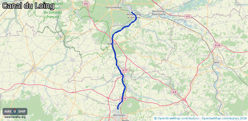
Route:
Please wait, loading route graphic...
Request waterway overview map with symbol legend here (Link).
Information about data associated with this body of water (25 available):
Data by OpenSeaMap (c) OSM contributors, www.openseamap.org
| # | Kind | Coordinates | Name | Information |
|---|---|---|---|---|
| 1 | Marina | 48.18166,2.72296 | 2021-05-02T11:12:19Z | Port de Souppes-sur-Loing |
| 2 | Marina | 48.27095,2.69199 | 2021-05-02T11:12:19Z | Halte nautique de Nemours (canal) |
| 3 | Marina | 48.26924,2.69716 | 2021-05-02T11:12:19Z | Halte Nautique de Nemours (Loing) |
| 4 | Marina | 48.37786,2.81753 | 2025-06-16T10:01:12Z | Halte fluviale de Moret |
| 5 | Lock | 48.0209,2.72379 | Unknown | |
| 6 | Lock | 48.0278,2.72241 | Unknown | |
| 7 | Lock | 48.04451,2.7386 | Unknown | |
| 8 | Lock | 48.06709,2.75028 | Unknown | |
| 9 | Lock | 48.07431,2.75226 | Unknown | |
| 10 | Lock | 48.10001,2.76397 | Unknown | |
| 11 | Lock | 48.11183,2.75906 | Unknown | |
| 12 | Lock | 48.1175,2.75286 | Unknown | |
| 13 | Lock | 48.15591,2.74159 | Unknown | |
| 14 | Lock | 48.16505,2.73622 | Unknown | |
| 15 | Lock | 48.19898,2.71654 | Unknown | |
| 16 | Lock | 48.23729,2.70552 | Unknown | |
| 17 | Lock | 48.25154,2.69679 | Unknown | |
| 18 | Lock | 48.27218,2.69387 | Unknown | |
| 19 | Lock | 48.29311,2.69467 | Unknown | |
| 20 | Lock | 48.31592,2.72726 | Unknown | |
| 21 | Lock | 48.327,2.75147 | Unknown | |
| 22 | Lock | 48.33423,2.78094 | Unknown | |
| 23 | Lock | 48.35074,2.81019 | Unknown | |
| 24 | Lock | 48.37059,2.82584 | Unknown | |
| 25 | Lock | 48.37667,2.82037 | Unknown |