Waterway information

Kind:
Inland
Driving areas:
🇫🇷 France🌊 Sea Mediterranean
Length:
71.9 km¹
¹River kilometers or bank length recorded in NavShip, including river arms and harbor entrances.
Availability:
Completely recorded
Recent Update: 17.04.2025²
² This date indicates when an adjustment last took place in the course of the body of water
Recorded:
Locks: 3
Harbours / marinas: 4
Bridges: 0
Berths: 6
Slipways: 0
Fuelstations: 0
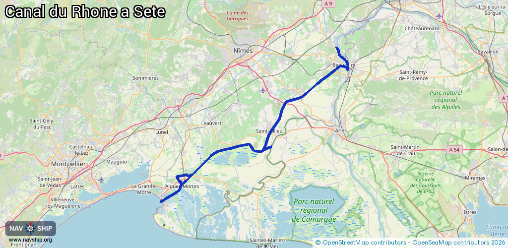
Route:
Please wait, loading route graphic...
Request waterway overview map with symbol legend here (Link).
Information about data associated with this body of water (13 available):
Data by OpenSeaMap (c) OSM contributors, www.openseamap.org
| # | Kind | Coordinates | Name | Information |
|---|---|---|---|---|
| 1 | Marina | 43.80555,4.64278 | 2017-08-29T03:54:42Z | Port de Beaucaire +33 4 66 59 02 17 http://www.laterredargence.fr/?q=content/les-3-ports-de-la-communaute-de-communes |
| 2 | Marina | 43.74392,4.51891 | 2013-07-29T14:13:20Z | Port de Bellegarde +33 4 66 59 02 17 http://www.laterredargence.fr/?q=content/les-3-ports-de-la-communaute-de-communes-0 |
| 3 | Marina | 43.56711,4.18728 | 2025-07-14T09:46:25Z | Port de Plaisance d'Aigues-Mortes |
| 4 | Marina | 43.63762,4.29613 | 2023-06-29T11:57:18Z | Port de Plaisance de Gallician |
| 5 | Berth | 43.58816,4.21145 | 2019-10-11T21:27:25Z | |
| 6 | Berth | 43.58892,4.19738 | 2019-10-11T21:27:25Z | 24_hour |
| 7 | Berth | 43.58943,4.20242 | 2019-10-11T21:27:25Z | |
| 8 | Berth | 43.58932,4.1999 | 2019-10-11T21:27:25Z | |
| 9 | Berth | 43.58842,4.1942 | 2019-10-11T21:27:25Z | |
| 10 | Berth | 43.58672,4.17722 | 2019-10-11T21:07:28Z | |
| 11 | Lock | 43.80145,4.64665 | Unknown | |
| 12 | Lock | 43.77676,4.57362 | Unknown | |
| 13 | Lock | 43.64434,4.43279 | Unknown |