Waterway information

Kind:
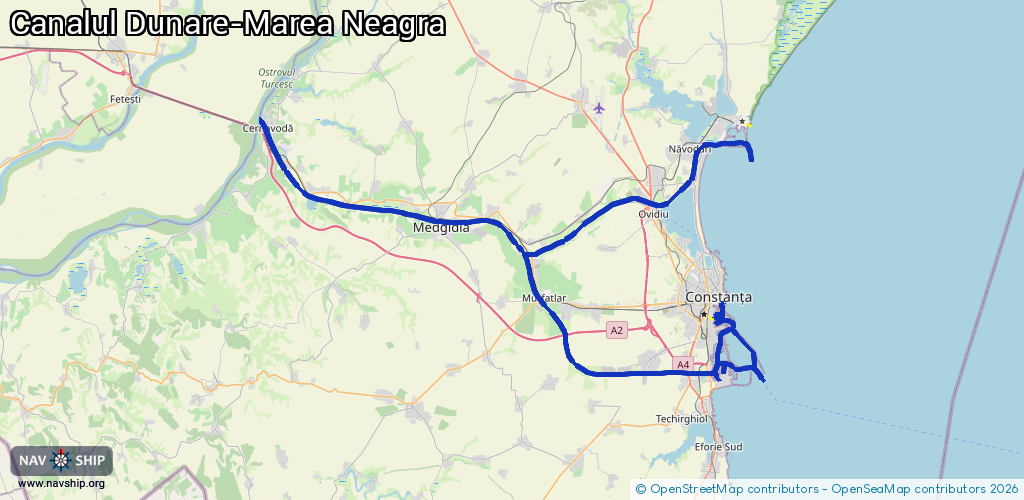
Inland
Driving areas:
🌊 Black Sea🇷🇴 Romania
Length:
122.8 km¹
¹River kilometers or bank length recorded in NavShip, including river arms and harbor entrances.
Availability:
Completely recorded
Recent Update: 15.04.2025²
² This date indicates when an adjustment last took place in the course of the body of water
Recorded:
Locks: 4
Harbours / marinas: 6
Bridges: 0
Berths: 0
Slipways: 0
Fuelstations: 0
Route:
Please wait, loading route graphic...
Request waterway overview map with symbol legend here (Link).
Information about data associated with this body of water (8 available):
Data by OpenSeaMap (c) OSM contributors, www.openseamap.org
| # | Kind | Coordinates | Name | Information |
|---|---|---|---|---|
| 1 | Marina | 44.17695,28.66353 | 2025-11-07T15:59:04Z | Portul Turistic Tomis |
| 2 | Marina | 44.1614,28.65601 | 2024-02-14T14:14:53Z | Doc uscat Sorena |
| 3 | Marina | 44.15965,28.65982 | 2023-08-24T16:47:35Z | Dana Tehnică |
| 4 | Marina | 44.15879,28.65827 | 2025-04-08T16:03:00Z | Dana Pasageri |
| 5 | Marina | 44.13682,28.6587 | 2025-04-08T16:03:00Z | Port Constanța,Incinta Port Constanța [email protected] +40 241 611 540 https://www.portofconstantza.com |
| 6 | Marina | 44.09958,28.70314 | 2019-12-27T17:13:37Z | Portul Constanța |
| 6 | Marina | 44.09958,28.70314 | 2019-12-27T17:13:37Z | Portul Constanța |
| 6 | Marina | 44.09958,28.70314 | 2019-12-27T17:13:37Z | Portul Constanța |
| 7 | Lock | 44.32248,28.62564 | Unknown | |
| 8 | Lock | 44.27101,28.54566 | Unknown |