Waterway information

Kind:
Inland
Driving areas:
🇺🇸 United States of America
Length:
12.9 km¹
¹River kilometers or bank length recorded in NavShip, including river arms and harbor entrances.
Availability:
Completely recorded
Recent Update: 01.12.2023²
² This date indicates when an adjustment last took place in the course of the body of water
Recorded:
Locks: 0
Harbours / marinas: 7
Bridges: 0
Berths: 0
Slipways: 1
Fuelstations: 4
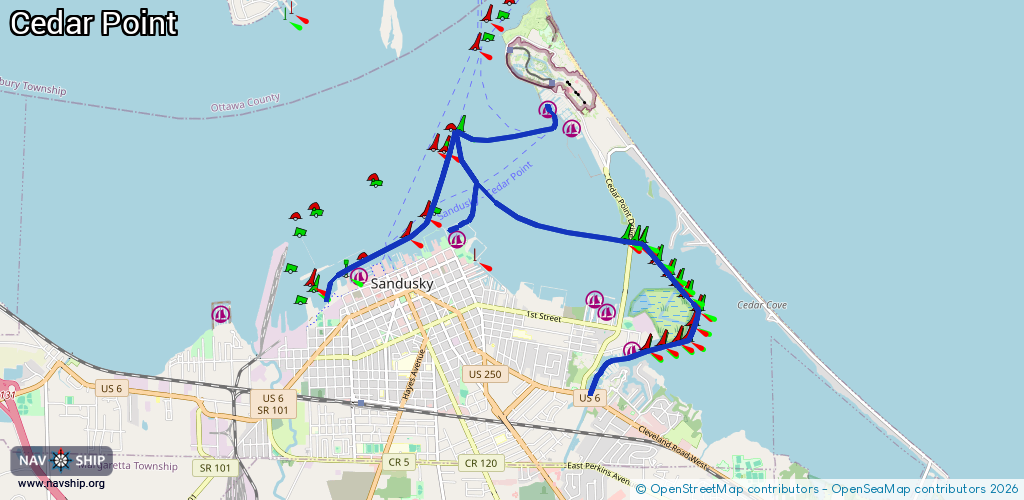
Route:
Please wait, loading route graphic...
Request waterway overview map with symbol legend here (Link).
Information about data associated with this body of water (12 available):
Data by OpenSeaMap (c) OSM contributors, www.openseamap.org
| # | Kind | Coordinates | Name | Information |
|---|---|---|---|---|
| 1 | Marina | 41.44739,-82.67206 | 2015-10-10T13:40:48Z | Holiday Marina |
| 2 | Marina | 41.45392,-82.67852 | 2015-10-10T13:40:51Z | Oando Marina |
| 3 | Marina | 41.45303,-82.67645 | 2019-02-19T10:44:15Z | Venetian Marina +1-419-625-2515 https://www.hotymarine.com/marinas/venetian-marina/ |
| 4 | Marina | 41.4613,-82.70261 | 2015-10-10T13:41:07Z | Battery Park Marina |
| 5 | Marina | 41.4771,-82.68281 | 2025-11-10T17:49:12Z | Cedar Point Marina +1-419-627-2334 https://www.cedarpoint.com/stay/marinas |
| 6 | Marina | 41.4784,-82.68656 | 2020-09-09T22:47:29Z | Cedar Point Marina https://www.cedarpoint.com/stay/marinas |
| 7 | Marina | 41.45687,-82.71897 | 2015-10-10T13:40:53Z | Deepwater Marina |
| 8 | Slipway | 41.45346,-82.72439 | small_craft_facility | 2015-10-10T13:40:51Z 4 Ramps |
| 9 | Fuel station | 41.45402,-82.67548 | 2015-10-10T13:40:51Z | Venetian Maria |
| 10 | Fuel station | 41.44397,-82.67672 | 2020-09-10T17:55:52Z | |
| 11 | Fuel station | 41.46346,-82.70158 | 2015-10-10T13:40:58Z | |
| 12 | Fuel station | 41.47898,-82.68628 | 2015-10-10T13:41:08Z |