Waterway information

Kind:
Inland
Driving areas:
🇺🇸 United States of America
Length:
8 km¹
¹River kilometers or bank length recorded in NavShip, including river arms and harbor entrances.
Availability:
Completely recorded
Recent Update: 07.04.2025²
² This date indicates when an adjustment last took place in the course of the body of water
Recorded:
Locks: 0
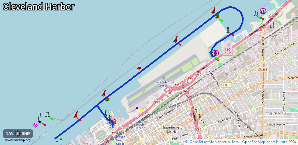
Harbours / marinas: 3
Bridges: 0
Berths: 2
Slipways: 0
Fuelstations: 0
Route:
Please wait, loading route graphic...
Request waterway overview map with symbol legend here (Link).
Information about data associated with this body of water (5 available):
Data by OpenSeaMap (c) OSM contributors, www.openseamap.org
| # | Kind | Coordinates | Name | Information |
|---|---|---|---|---|
| 1 | Marina | 41.52423,-81.66587 | 2015-10-09T09:42:24Z | Lakeside Yacht Club, Inc |
| 2 | Marina | 41.53351,-81.65186 | 2015-10-09T09:42:26Z | East 55th Street Marina |
| 3 | Marina | 41.509,-81.69634 | 2021-12-01T21:22:52Z | Rock & Dock Marina |
| 4 | Berth | 41.5097,-81.69268 | 2025-02-09T12:34:04Z | USCGC Neah Bay USCGC NEAH BAY is a 140 foot Icebreaking Tug. Missions include Icebreaking, Homeland Security, and Law Enforcement. NEAH BAY serves throughout the entire Great Lakes system and has earned the nickname Jack of All Trades. https://www.dvidshub.net/image/1089818/neah-bay-breaks-ice |
| 5 | Berth | 41.50985,-81.69324 | 2025-02-09T12:34:04Z | USCGC Morro Bay USCGC MORRO BAY is a 140 foot Icebreaking Tug. Missions include Icebreaking, Homeland Security, and Law Enforcement. MORRO BAY serves throughout the entire Great Lakes system and has earned the nickname Jack of All Trades. https://www.dvidshub.net/image/1099783/morro-bay-rescues-snowmobiler |