Waterway information

Kind:
Inland
Driving areas:
🌊 Pacific Ocean🇺🇸 United States of America
Length:
939.7 km¹, 0 km official total length
¹River kilometers or bank length recorded in NavShip, including river arms and harbor entrances.
Availability:
Completely recorded
Recent Update: 10.12.2025²
² This date indicates when an adjustment last took place in the course of the body of water
Recorded:
Locks: 4
Harbours / marinas: 30
Bridges: 5
Berths: 8
Slipways: 0
Fuelstations: 0
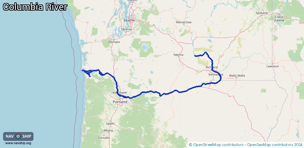
Route:
Please wait, loading route graphic...
Request waterway overview map with symbol legend here (Link).
Information about data associated with this body of water (46 available):
Data by OpenSeaMap (c) OSM contributors, www.openseamap.org
| # | Kind | Coordinates | Name | Information |
|---|---|---|---|---|
| 1 | Marina | 47.85436,-118.34205 | 2025-11-25T16:15:30Z | Seven Bays Marina |
| 2 | Marina | 45.55843,-122.46209 | 2022-07-14T00:50:19Z | Big Eddy Marina |
| 3 | Marina | 45.55889,-122.46743 | 2022-07-14T00:50:19Z | Islands Moorage |
| 4 | Marina | 45.56001,-122.47147 | 2022-07-14T00:50:19Z | Ducks Moorage |
| 5 | Marina | 45.5598,-122.47366 | 2022-07-14T00:50:19Z | Columbia Ridge Marina |
| 6 | Marina | 45.55952,-122.47892 | 2022-07-14T00:50:19Z | McGuire Point Marina |
| 7 | Marina | 45.60184,-122.63591 | 2021-08-04T23:02:18Z | McCuddy's Marine Drive Moorage |
| 8 | Marina | 45.60398,-122.65846 | 2021-07-26T15:56:25Z | Sundance Marina |
| 9 | Marina | 45.60599,-122.65571 | 2021-07-26T15:56:25Z | Tomahawk Bay Marina |
| 10 | Marina | 45.60723,-122.6601 | 2021-07-26T15:56:25Z | Salpare Bay Marina |
| 11 | Marina | 45.60372,-122.66078 | 2021-07-26T15:56:25Z | Tomahawk Island Marina |
| 12 | Marina | 45.60409,-122.66382 | 2024-07-27T19:49:05Z | McCuddy's Hayden Island Moorage |
| 13 | Marina | 45.608,-122.66392 | 2025-12-22T04:41:08Z | Columbia River Yacht Club https://www.cryc.com/ |
| 14 | Marina | 45.60811,-122.66871 | 2021-07-26T15:56:25Z | Hayden Bay Marina |
| 15 | Marina | 45.60677,-122.67471 | 2021-08-01T03:07:41Z | Island Cove |
| 16 | Marina | 45.60826,-122.67774 | 2023-08-09T05:51:20Z | Jantzen Bay Marina |
| 17 | Marina | 46.20638,-123.38786 | 2020-12-22T18:28:17Z | Elochoman Slough Marina |
| 18 | Marina | 46.20331,-123.95059 | 2024-06-27T20:40:48Z | Hammond Marina https://www.ci.warrenton.or.us/marinas |
| 19 | Marina | 46.17065,-123.82115 | 2021-08-24T15:40:31Z | Blue Heron Marina |
| 20 | Marina | 46.17018,-123.83694 | 2021-08-24T15:40:31Z | |
| 21 | Marina | 45.85761,-119.8513 | 2025-02-14T19:34:36Z | Crow Butte Park Marina |
| 22 | Marina | 46.2653,-119.25381 | 2024-09-06T20:14:35Z | Columbia Point Marina |
| 23 | Marina | 45.92032,-119.16396 | 2025-10-31T01:38:19Z | McNary Yacht Club https://mcnaryyachtclub.com/ |
| 24 | Marina | 45.60132,-121.17312 | 2024-02-08T19:28:44Z | |
| 25 | Marina | 45.60125,-121.17278 | 2026-02-05T02:48:55Z | Port of The Dalles Marina |
| 26 | Marina | 45.67181,-121.89202 | 2025-03-13T10:38:27Z | |
| 27 | Marina | 45.57776,-122.38065 | 2021-12-21T05:18:12Z | The Port https://portcw.com/ |
| 28 | Marina | 45.61209,-122.61248 | 2021-07-26T15:56:25Z | Tidewater Cove Marina |
| 29 | Marina | 46.19529,-123.80285 | 2021-08-24T15:40:31Z | East Mooring Basin |
| 30 | Marina | 46.18968,-123.85561 | 2021-08-24T15:40:31Z | West Mooring Basin |
| 31 | Bridge | 46.19651,-123.38358 | 65.5 | Clearance height: 2023-09-01T04:52:26Z m Maximum passage width: 22.8 m Movable bridge (e.g. lifting bridge or drawbridge) fixed |
| 32 | Bridge | 46.16881,-123.83819 | Unknown | Clearance height: 2023-08-28T04:55:57Z m Maximum passage width: 7.3 m bascule |
| 33 | Bridge | 46.17611,-123.86839 | 39.6 | Clearance height: 2023-08-28T04:55:57Z m Maximum passage width: 11.8 m Movable bridge (e.g. lifting bridge or drawbridge) lifting |
| 34 | Bridge | 46.19366,-123.85096 | 326.1 | Clearance height: 2023-09-01T03:16:59Z m Maximum passage width: 62.4 m Movable bridge (e.g. lifting bridge or drawbridge) fixed |
| 35 | Bridge | 46.23728,-123.87308 | 91.4 | Clearance height: 2023-09-01T03:16:59Z m Maximum passage width: 14.6 m Movable bridge (e.g. lifting bridge or drawbridge) fixed |
| 36 | Berth | 45.63321,-122.7084 | 2024-07-23T23:45:10Z | Vancouver Upper Anchorage Lighted Buoy VV anchorage |
| 37 | Berth | 45.63917,-122.72444 | 2024-07-23T23:45:10Z | Hayden Island Anchorage Lighted Buoy B anchorage |
| 38 | Berth | 45.64444,-122.74167 | 2024-07-23T23:45:10Z | Hayden Island Anchorage Lighted Buoy A anchorage |
| 39 | Berth | 45.66808,-122.76748 | 2024-07-20T06:05:40Z | Lower Vancouver Anchorage Lighted Buoy V anchorage |
| 40 | Berth | 46.20588,-123.78829 | 2023-08-31T06:07:29Z | |
| 41 | Berth | 46.20286,-123.81544 | 2023-08-31T06:07:29Z | |
| 42 | Berth | 46.19041,-123.82519 | 2023-11-18T15:13:24Z | USCGC Alert U.S. Coast Guard 210' cutters patrol from Russian Maritime Boundary Line in the Bering Sea to the Central and South American coasts. Missions include: counter-drug, alien migration interdiction, homeland security and search and rescue operations. https://www.dvidshub.net/image/3459588/portland-rose-festival |
| 43 | Berth | 46.19051,-123.82354 | 2023-11-18T15:13:24Z | USCGC Steadfast U.S. Coast Guard 210' cutters patrol from Russian Maritime Boundary Line in the Bering Sea to the Central and South American coasts. Missions include: counter-drug, alien migration interdiction, homeland security and search and rescue operations. https://www.dvidshub.net/image/2585452/uscgc-steadfast-returns-59-day-patrol |
| 44 | Lock | 45.94005,-119.30088 | Unknown | |
| 44 | Lock | 45.94005,-119.30088 | Unknown | |
| 45 | Lock | 45.61488,-121.13989 | Unknown | |
| 46 | Lock | 45.63853,-121.94693 | Unknown |