Waterway information

Kind:
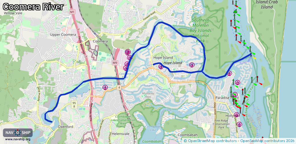
Inland
Driving areas:
🇦🇺 Australia🌊 Pacific Ocean
Length:
21.5 km¹
¹River kilometers or bank length recorded in NavShip, including river arms and harbor entrances.
Availability:
Completely recorded
Recent Update: 12.09.2024²
² This date indicates when an adjustment last took place in the course of the body of water
Recorded:
Locks: 0
Harbours / marinas: 9
Bridges: 0
Berths: 0
Slipways: 1
Fuelstations: 0
Route:
Please wait, loading route graphic...
Request waterway overview map with symbol legend here (Link).
Information about data associated with this body of water (10 available):
Data by OpenSeaMap (c) OSM contributors, www.openseamap.org
| # | Kind | Coordinates | Name | Information |
|---|---|---|---|---|
| 1 | Marina | -27.87006,153.35638 | 2024-02-16T10:29:04Z | Cova Marina |
| 2 | Marina | -27.86942,153.37556 | 2024-02-22T04:31:12Z | Hope Harbour Marina |
| 3 | Marina | -27.87356,153.39729 | 2025-06-07T09:36:29Z | Salacia Marina |
| 4 | Marina | -27.8809,153.3234 | 2021-01-22T12:24:38Z | Moorings On Coomera |
| 5 | Marina | -27.87067,153.33542 | 2024-12-15T00:09:49Z | |
| 6 | Marina | -27.86871,153.33621 | 2025-04-07T00:57:00Z | |
| 7 | Marina | -27.86541,153.33759 | 2025-04-07T00:57:00Z | |
| 8 | Marina | -27.86205,153.33679 | 2022-10-31T04:24:44Z | Gold Coast City Marina |
| 9 | Marina | -27.86259,153.33725 | 2025-04-07T00:57:00Z | |
| 10 | Slipway | -27.87072,153.33531 | Unknown | 2024-12-15T00:09:49Z |