Waterway information

Kind:
Inland
Driving areas:
🇺🇸 United States of America
Length:
16.8 km¹
¹River kilometers or bank length recorded in NavShip, including river arms and harbor entrances.
Availability:
Completely recorded
Recent Update: 02.09.2025²
² This date indicates when an adjustment last took place in the course of the body of water
Recorded:
Locks: 1
Harbours / marinas: 4
Bridges: 0
Berths: 0
Slipways: 1
Fuelstations: 1
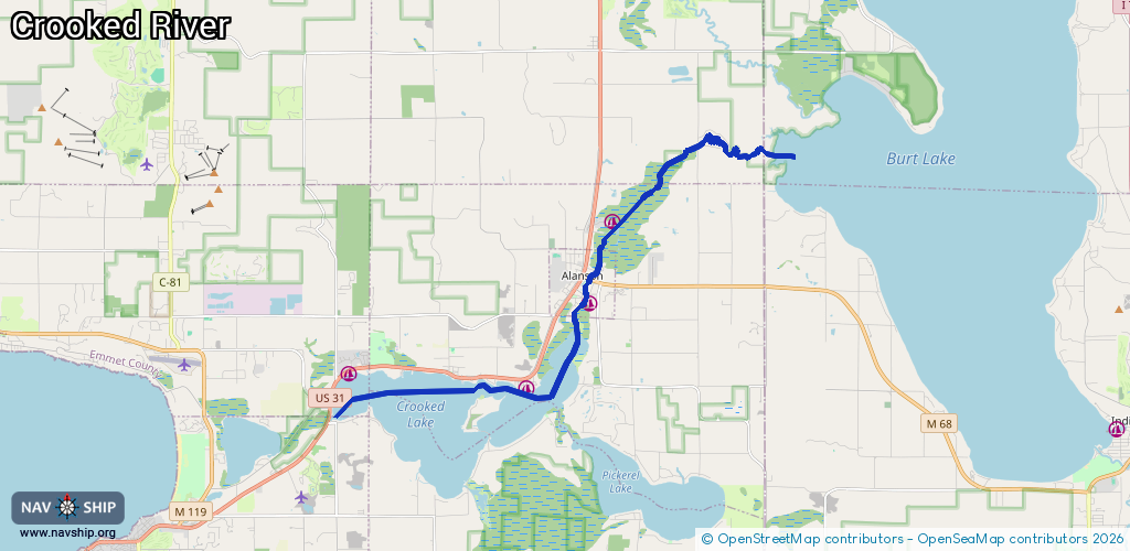
Route:
Please wait, loading route graphic...
Request waterway overview map with symbol legend here (Link).
Information about data associated with this body of water (6 available):
Data by OpenSeaMap (c) OSM contributors, www.openseamap.org
| # | Kind | Coordinates | Name | Information |
|---|---|---|---|---|
| 1 | Marina | 45.42271,-84.85935 | 2025-06-09T17:00:39Z | Petoskey Outboard Cruising Club |
| 2 | Marina | 45.41952,-84.80406 | 2025-06-04T16:46:03Z | Ryde Marine [email protected] +1-231-347-8273 https://www.rydemarine.com/ |
| 3 | Marina | 45.43866,-84.78502 | 2025-05-27T14:58:53Z | Marooners' Rock Marina +1-231-373-2265 https://maroonersrockmarina.com/ |
| 4 | Marina | 45.45562,-84.77668 | 2025-05-30T15:40:58Z | Hay Lake Park Marina [email protected] https://www.littlefieldtwp.org/departments/hay-lake-park-marina/ |
| 5 | Slipway | 45.42246,-84.85933 | Unknown | 2025-06-09T17:00:39Z |
| 6 | Fuel station | 45.41941,-84.8043 | 2025-06-04T16:46:03Z | |
| 6 | Fuel station | 45.41941,-84.8043 | 2025-06-04T16:46:03Z |