Waterway information

Kind:
Inland
Driving areas:
🌊 North Sea🇬🇧 United Kingdom
Length:
6.5 km¹
¹River kilometers or bank length recorded in NavShip, including river arms and harbor entrances.
Availability:
Completely recorded
Recent Update: 21.08.2023²
² This date indicates when an adjustment last took place in the course of the body of water
Recorded:
Locks: 0
Harbours / marinas: 2
Bridges: 0
Berths: 3
Slipways: 0
Fuelstations: 0
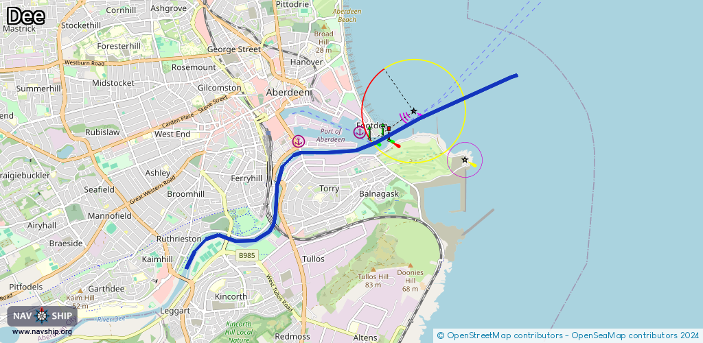
Route:
Please wait, loading route graphic...
Request waterway overview map with symbol legend here (Link).
Information about data associated with this body of water (5 available):
Data by OpenSeaMap (c) OSM contributors, www.openseamap.org
| # | Kind | Coordinates | Name | Information |
|---|---|---|---|---|
| 1 | Marina | 57.14144,-2.09005 | 2024-03-18T13:51:30Z | Yard |
| 2 | Marina | 57.14269,-2.07193 | 2025-06-03T18:07:17Z | Port of Aberdeen (North Harbour) https://www.portofaberdeen.co.uk |
| 3 | Berth | 57.14529,-2.09175 | 2022-10-16T18:51:32Z | Northern Isles Ferry Berth |
| 4 | Berth | 57.14327,-2.08798 | 2022-10-13T21:38:12Z | Eurolink Berth |
| 5 | Berth | 57.1436,-2.0816 | 2022-10-13T21:38:12Z | Ro-Ro Ramp |