Waterway information

Kind:
Inland
Driving areas:
🇳🇱 Netherlands
Length:
5.8 km¹
¹River kilometers or bank length recorded in NavShip, including river arms and harbor entrances.
Availability:
Completely recorded
Recent Update: 01.11.2022²
² This date indicates when an adjustment last took place in the course of the body of water
Recorded:
Locks: 0
Harbours / marinas: 4
Bridges: 4
Berths: 0
Slipways: 0
Fuelstations: 0
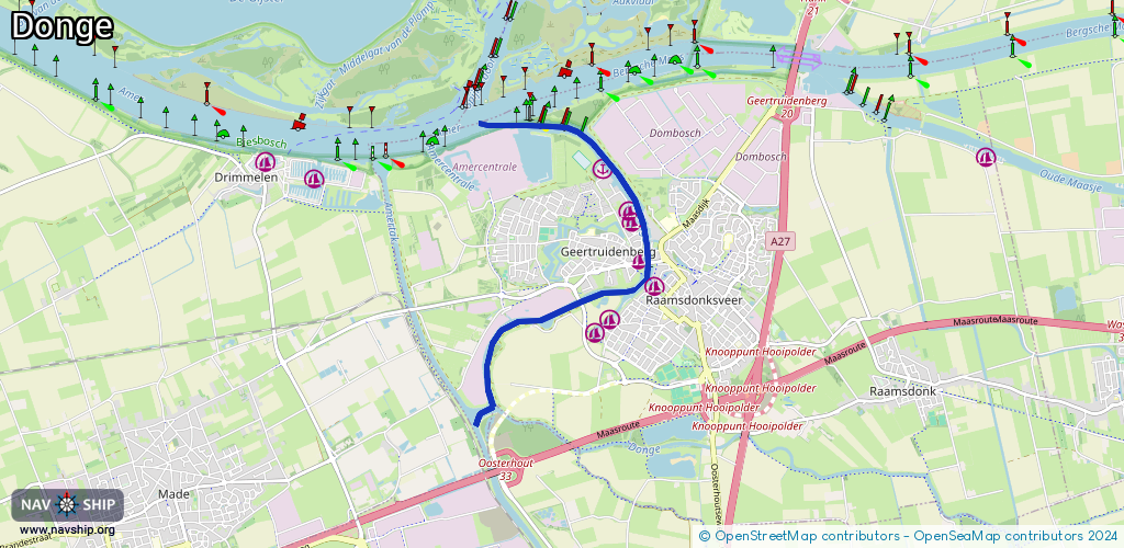
Route:
Please wait, loading route graphic...
Request waterway overview map with symbol legend here (Link).
Information about data associated with this body of water (8 available):
Data by OpenSeaMap (c) OSM contributors, www.openseamap.org
| # | Kind | Coordinates | Name | Information |
|---|---|---|---|---|
| 1 | Marina | 51.69999,4.86587 | 2019-01-20T17:49:39Z | Passantenhaven Geertruidenberg |
| 2 | Marina | 51.70363,4.86493 | 2021-03-16T19:47:15Z | W.S.V. Geertruidenberg Max. 12x4m Boten http://www.wsvgeertruidenberg.nl/ |
| 3 | Marina | 51.70469,4.86432 | 2023-11-17T19:24:38Z | WSV de Donge https://www.wsvdedonge.nl |
| 4 | Marina | 51.70882,4.8603 | 2019-01-19T22:51:37Z | |
| 5 | Bridge | 51.69595,4.85675 | 19.92 | Clearance height: 2019-01-19T19:22:51Z m Maximum passage width: 5.58 m Movable bridge (e.g. lifting bridge or drawbridge) fixed |
| 6 | Bridge | 51.69831,4.86714 | 20 | Clearance height: 2021-03-16T19:47:15Z m Maximum passage width: 5.6 m Movable bridge (e.g. lifting bridge or drawbridge) fixed |
| 7 | Bridge | 51.69971,4.86762 | 11.80 | Clearance height: 2013-12-08T14:51:49Z m Maximum passage width: 7.25 m Movable bridge (e.g. lifting bridge or drawbridge) fixed |
| 8 | Bridge | 51.69971,4.86725 | 21.60 | Clearance height: 2013-12-08T14:51:49Z m Maximum passage width: 6.25 m Movable bridge (e.g. lifting bridge or drawbridge) fixed |