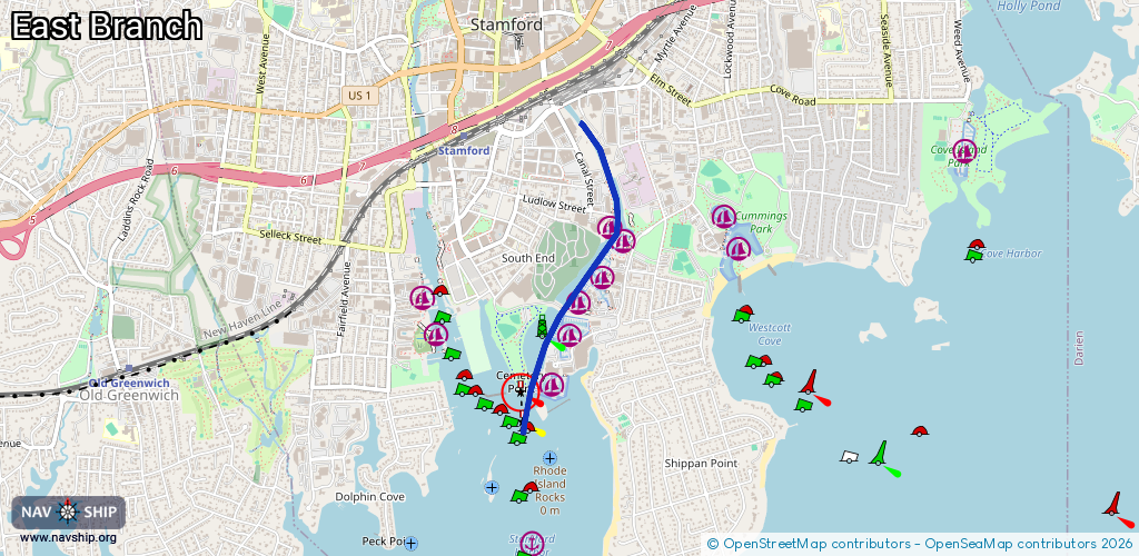
Waterway information

Kind:
Inland
Driving areas:
🌊 Atlantic Ocean🇺🇸 United States of America
Length:
2.2 km¹
¹River kilometers or bank length recorded in NavShip, including river arms and harbor entrances.
Availability:
Completely recorded
Recent Update: 09.02.2024²
² This date indicates when an adjustment last took place in the course of the body of water
Recorded:
Locks: 0
Harbours / marinas: 6
Bridges: 0
Berths: 0
Slipways: 0
Fuelstations: 0
Route:
Please wait, loading route graphic...
Request waterway overview map with symbol legend here (Link).
Information about data associated with this body of water (6 available):
Data by OpenSeaMap (c) OSM contributors, www.openseamap.org
| # | Kind | Coordinates | Name | Information |
|---|---|---|---|---|
| 1 | Marina | 41.0408,-73.52969 | 2025-03-17T12:18:33Z | Czecik Marina |
| 2 | Marina | 41.04135,-73.53091 | 2025-08-14T21:26:58Z | |
| 3 | Marina | 41.03819,-73.53128 | 2025-08-14T21:26:58Z | |
| 4 | Marina | 41.0371,-73.53316 | 2022-03-29T11:28:11Z | |
| 5 | Marina | 41.03516,-73.53395 | 2026-02-09T03:37:21Z | Safe Harbor Yacht Haven https://shmarinas.com/locations/safe-harbor-yacht-haven/ |
| 6 | Marina | 41.03283,-73.53542 | 2025-12-01T16:50:01Z | Safe Harbor Yacht Haven [email protected] +1-203-359-4500 https://www.byy.com/marinas/brewer-yacht-haven-marina-stamford-ct/ |