Waterway information

Kind:
Inland
Driving areas:
🌊 Atlantic Ocean🇺🇸 United States of America
Length:
156.9 km¹
¹River kilometers or bank length recorded in NavShip, including river arms and harbor entrances.
Availability:
Completely recorded
Recent Update: 02.10.2025²
² This date indicates when an adjustment last took place in the course of the body of water
Recorded:
Locks: 0
Harbours / marinas: 12
Bridges: 0
Berths: 31
Slipways: 0
Fuelstations: 0
Route:
Please wait, loading route graphic...
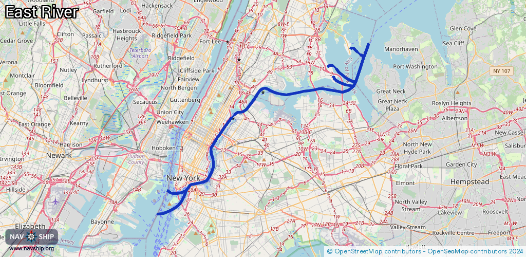
Request waterway overview map with symbol legend here (Link).
Information about data associated with this body of water (43 available):
Data by OpenSeaMap (c) OSM contributors, www.openseamap.org
| # | Kind | Coordinates | Name | Information |
|---|
| 1 | Marina | 31.04614,-81.42215 | 2022-10-05T01:18:28Z | Jekyll Island Marina |
| 2 | Marina | 40.81344,-73.80334 | 2024-09-03T21:23:11Z | Locust Point Yacht Club |
| 3 | Marina | 40.81606,-73.80563 | 2024-09-03T22:15:40Z | Hammonds' Cove Marina |
| 4 | Marina | 31.15184,-81.54678 | 2022-09-30T22:01:26Z | Blythe Island Marina |
| 5 | Marina | 31.15691,-81.49976 | 2022-09-30T22:28:26Z | |
| 6 | Marina | 30.86768,-81.58469 | 2022-12-23T18:39:08Z | Harriets Bluff Public Boat Ramp |
| 7 | Marina | 40.69616,-74.00066 | 2024-06-28T13:41:24Z | One15 Marina |
| 8 | Marina | 40.82508,-73.81428 | 2022-09-09T14:41:39Z | Bronxonia Yacht Club |
| 9 | Marina | 40.84322,-73.78476 | 2021-03-30T17:19:41Z | Minneford Marina |
| 10 | Marina | 40.81194,-73.76437 | 2024-05-02T20:56:12Z | Hague Basin |
| 11 | Marina | 40.79499,-73.84208 | 2022-11-16T23:14:14Z | College Point Yacht Club
http://www.collegepointyachtclub.org/ |
| 12 | Marina | 40.73572,-73.9737 | 2022-07-15T02:50:39Z | Skyport Marina
+1-212-481-4806
http://docknyc.com/sites-locations/manhattan/skyport/ |
| 13 | Berth | 40.75987,-73.94723 | 2024-01-03T22:12:02Z | |
| 14 | Berth | 40.76129,-73.94616 | 2024-01-03T22:12:02Z | |
| 15 | Berth | 40.75881,-73.94808 | 2024-01-03T22:12:02Z | |
| 16 | Berth | 40.70444,-73.97592 | 2024-01-03T22:12:02Z | 16 |
| 17 | Berth | 40.70432,-73.97598 | 2024-01-03T22:12:02Z | 15 |
| 18 | Berth | 40.70421,-73.97603 | 2024-01-03T22:12:02Z | 14 |
| 19 | Berth | 40.7041,-73.97609 | 2024-01-03T22:12:02Z | 13 |
| 20 | Berth | 40.70399,-73.97615 | 2024-01-03T22:12:02Z | 12 |
| 21 | Berth | 40.70387,-73.9762 | 2024-01-03T22:12:02Z | 11 |
| 22 | Berth | 40.70375,-73.97627 | 2024-01-03T22:12:02Z | 10 |
| 23 | Berth | 40.70365,-73.97632 | 2024-01-03T22:12:02Z | 9 |
| 24 | Berth | 40.70354,-73.97637 | 2024-01-03T22:12:02Z | 8 |
| 25 | Berth | 40.70343,-73.97643 | 2024-01-03T22:12:02Z | 7 |
| 26 | Berth | 40.70332,-73.97648 | 2024-01-03T22:12:02Z | 6 |
| 27 | Berth | 40.70321,-73.97654 | 2024-01-03T22:12:02Z | 5 |
| 28 | Berth | 40.70309,-73.9766 | 2024-01-03T22:12:02Z | 4 |
| 29 | Berth | 40.70298,-73.97666 | 2024-01-03T22:12:02Z | 3 |
| 30 | Berth | 40.70287,-73.97671 | 2024-01-03T22:12:02Z | 2 |
| 31 | Berth | 40.70278,-73.97676 | 2024-01-03T22:12:02Z | 1 |
| 32 | Berth | 40.70461,-73.97652 | 2024-01-03T22:12:02Z | 17 |
| 33 | Berth | 40.7045,-73.97658 | 2024-01-03T22:12:02Z | 18 |
| 34 | Berth | 40.70438,-73.97664 | 2024-01-03T22:12:02Z | 19 |
| 35 | Berth | 40.70427,-73.9767 | 2024-01-03T22:12:02Z | 20 |
| 36 | Berth | 40.70416,-73.97675 | 2024-01-03T22:12:02Z | 21 |
| 37 | Berth | 40.70403,-73.97682 | 2024-01-03T22:12:02Z | 22 |
| 38 | Berth | 40.70049,-74.01186 | 2024-01-03T22:12:02Z | 5 |
| 39 | Berth | 40.70057,-74.01153 | 2024-01-03T22:12:02Z | 6 |
| 40 | Berth | 40.70065,-74.01119 | 2024-01-03T22:12:02Z | 7 |
| 41 | Berth | 40.70039,-74.01244 | 2024-01-03T22:12:02Z | 3 |
| 42 | Berth | 40.70032,-74.01297 | 2024-01-03T22:12:02Z | 2 |
| 43 | Berth | 40.70026,-74.01336 | 2024-01-03T22:12:02Z | 1 |