Waterway information

Kind:
Inland
Driving areas:
🇳🇱 Netherlands
Length:
6.6 km¹
¹River kilometers or bank length recorded in NavShip, including river arms and harbor entrances.
Availability:
Completely recorded
Recent Update: 16.10.2024²
² This date indicates when an adjustment last took place in the course of the body of water
Recorded:
Locks: 0
Harbours / marinas: 9
Bridges: 13
Berths: 0
Slipways: 0
Fuelstations: 1
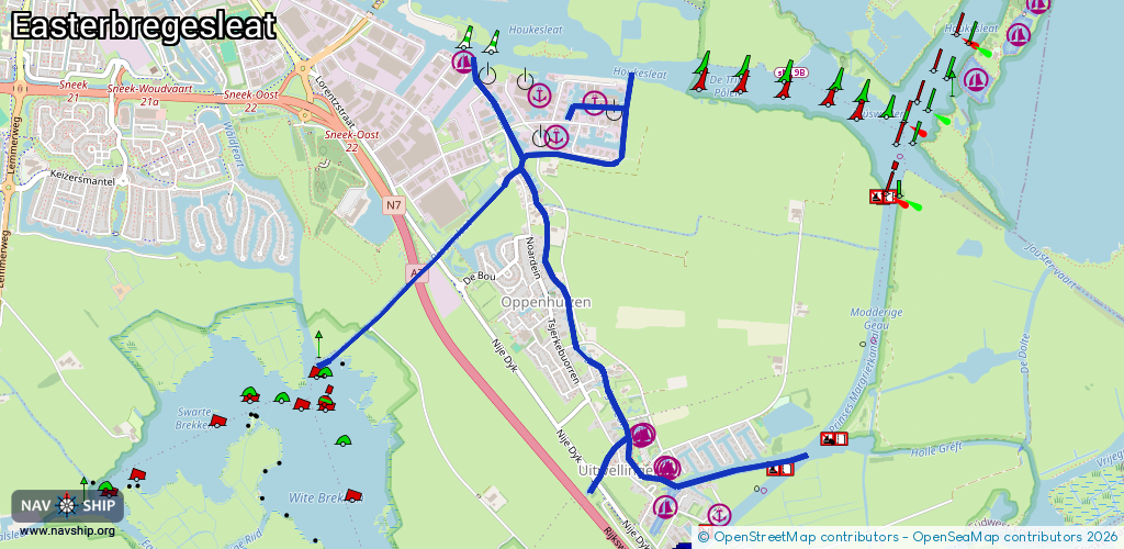
Route:
Please wait, loading route graphic...
Request waterway overview map with symbol legend here (Link).
Information about data associated with this body of water (23 available):
Data by OpenSeaMap (c) OSM contributors, www.openseamap.org
| # | Kind | Coordinates | Name | Information |
|---|---|---|---|---|
| 1 | Marina | 53.02349,5.69008 | 2022-05-27T06:41:25Z | |
| 2 | Marina | 53.00595,5.70418 | 2016-04-15T08:06:54Z | JH Hart van Friesland |
| 3 | Marina | 53.00573,5.70375 | 2024-03-14T08:38:54Z | |
| 4 | Marina | 53.0044,5.7059 | 2016-04-15T08:06:53Z | JH Hart van Friesland |
| 5 | Marina | 53.00429,5.70627 | 2024-03-14T08:38:54Z | |
| 6 | Marina | 53.00233,5.70578 | 2024-03-14T08:38:54Z | |
| 7 | Marina | 53.01988,5.69707 | 2025-05-26T17:41:55Z | Houkesleat |
| 8 | Marina | 53.02153,5.70028 | 2024-09-05T20:17:39Z | |
| 9 | Marina | 53.02196,5.69593 | 2025-05-26T17:41:55Z | Houkesleat |
| 10 | Bridge | 53.02036,5.69348 | 4 | Clearance height: 2020-05-09T14:39:38Z m Maximum passage width: 1.2 m fixed |
| 11 | Bridge | 53.01826,5.69475 | Unknown | Clearance height: 2015-08-13T09:56:01Z m Maximum passage width: 1.2 m opening |
| 12 | Bridge | 53.0169,5.69573 | Unknown | Clearance height: 2015-08-13T09:56:01Z m opening |
| 13 | Bridge | 53.0158,5.69661 | 4 | Clearance height: 2015-08-17T13:07:23Z m Maximum passage width: .85 m opening |
| 14 | Bridge | 53.01259,5.69652 | 2 | Clearance height: 2021-10-31T21:57:03Z m Maximum passage width: 1.35 m Movable bridge (e.g. lifting bridge or drawbridge) |
| 15 | Bridge | 53.01017,5.69878 | 4.1 | Clearance height: 2015-08-17T13:07:22Z m Maximum passage width: 1.55 m bascule |
| 16 | Bridge | 53.00725,5.70199 | 4 | Clearance height: 2015-08-17T13:07:41Z m Maximum passage width: 1.35 m opening |
| 17 | Bridge | 53.01308,5.68578 | Unknown | Clearance height: 2022-02-11T21:12:45Z m Movable bridge (e.g. lifting bridge or drawbridge) fixed Wandelbrug Broeresleat |
| 18 | Bridge | 53.01347,5.68642 | 5 | Clearance height: 2018-08-12T09:14:11Z m Maximum passage width: 2.5 m Movable bridge (e.g. lifting bridge or drawbridge) fixed |
| 19 | Bridge | 53.01432,5.68789 | 5 | Clearance height: 2018-08-12T09:14:12Z m Maximum passage width: 2.5 m fixed |
| 20 | Bridge | 53.01831,5.69404 | 5.1 | Clearance height: 2020-06-12T18:30:10Z m Maximum passage width: 1.1 m opening |
| 21 | Bridge | 53.00379,5.70043 | 3.7 | Clearance height: 2025-09-16T14:58:47Z m Maximum passage width: 1.55 m Movable bridge (e.g. lifting bridge or drawbridge) fixed |
| 22 | Bridge | 53.00539,5.70197 | 4 | Clearance height: 2015-08-13T09:56:05Z m Maximum passage width: 1.5 m Movable bridge (e.g. lifting bridge or drawbridge) fixed |
| 23 | Fuel station | 53.02236,5.69575 | 2017-03-04T10:11:27Z | Tankstation: Brandsma Jachten Diesel, Benzin |