Waterway information

Kind:
Inland
Driving areas:
🇩🇪 Germany
Length:
4.4 km¹
¹River kilometers or bank length recorded in NavShip, including river arms and harbor entrances.
Availability:
Completely recorded
Recent Update: 10.04.2025²
² This date indicates when an adjustment last took place in the course of the body of water
Recorded:
Locks: 0
Harbours / marinas: 3
Bridges: 3
Berths: 0
Slipways: 1
Fuelstations: 0
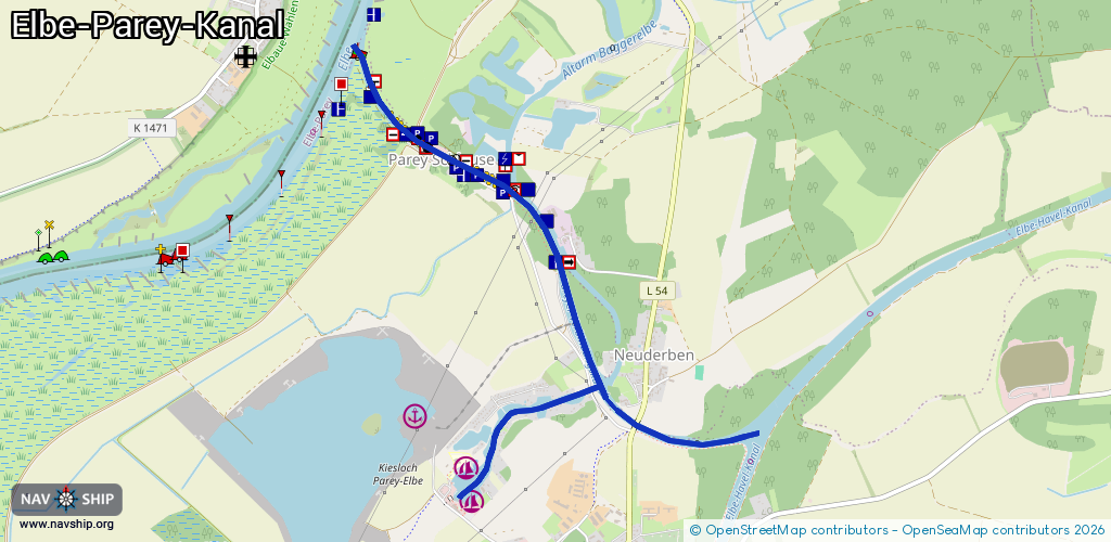
Route:
Please wait, loading route graphic...
Request waterway overview map with symbol legend here (Link).
Information about data associated with this body of water (7 available):
Data by OpenSeaMap (c) OSM contributors, www.openseamap.org
| # | Kind | Coordinates | Name | Information |
|---|---|---|---|---|
| 1 | Marina | 52.38677,11.98031 | 2021-09-28T11:38:49Z | Anleger Parey Gaststeg Gemeinde Elbe-Parey. betrieben v. Mein Lieblingsplatz“ |
| 2 | Marina | 52.38852,11.9802 | 2023-08-07T12:13:16Z | Wassersportverein Parey Mo-Su 18:00-20:00 https://www.wassersportverein-parey.de/ |
| 3 | Marina | 52.39089,11.97583 | 2023-01-31T21:44:49Z | Schubboot Tonja Schubboot für den Baggersee |
| 4 | Bridge | 52.38955,11.99859 | 20.50 | Clearance height: 2013-01-06T12:10:07Z m Maximum passage width: 5.55 m Movable bridge (e.g. lifting bridge or drawbridge) fixed |
| 5 | Bridge | 52.39045,11.99327 | 20 | Clearance height: 2012-11-12T14:53:51Z m Maximum passage width: 4.41 m Movable bridge (e.g. lifting bridge or drawbridge) fixed |
| 6 | Bridge | 52.40323,11.97894 | 10.3 | Clearance height: 2022-03-20T06:50:28Z m Maximum passage width: 5.26 m Movable bridge (e.g. lifting bridge or drawbridge) fixed |
| 7 | Slipway | 52.38829,11.97949 | small_craft_facility | 2012-12-21T14:05:29Z |