Waterway information

Kind:
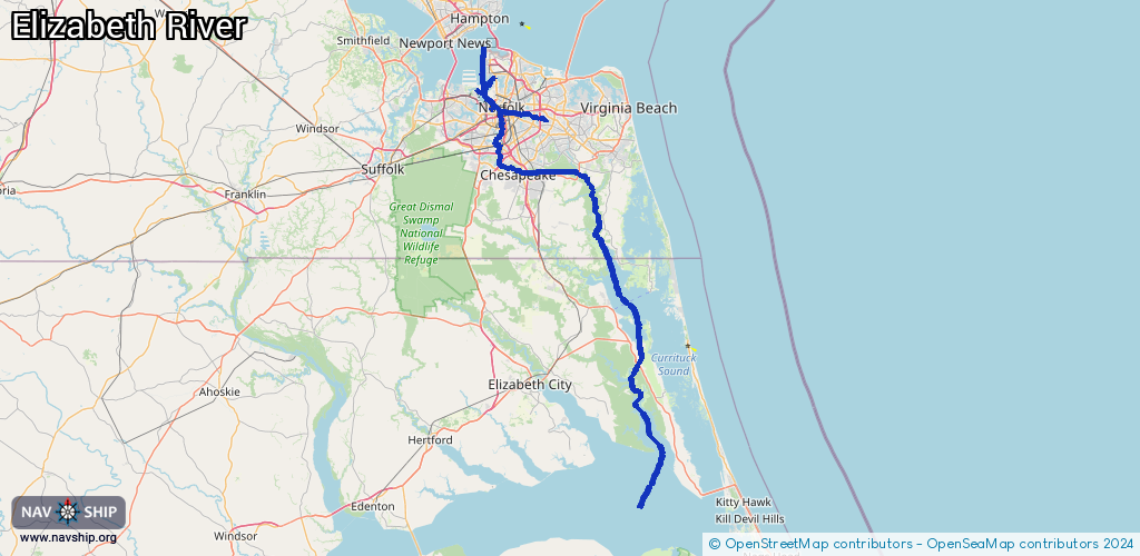
Inland
Driving areas:
🌊 Atlantic Ocean🇺🇸 United States of America
Length:
151.8 km¹
¹River kilometers or bank length recorded in NavShip, including river arms and harbor entrances.
Availability:
Completely recorded
Recent Update: 05.04.2025²
² This date indicates when an adjustment last took place in the course of the body of water
Recorded:
Locks: 1
Harbours / marinas: 8
Bridges: 11
Berths: 0
Slipways: 1
Fuelstations: 2
Route:
Please wait, loading route graphic...
Request waterway overview map with symbol legend here (Link).
Information about data associated with this body of water (23 available):
Data by OpenSeaMap (c) OSM contributors, www.openseamap.org
| # | Kind | Coordinates | Name | Information |
|---|---|---|---|---|
| 1 | Marina | 36.8455,-76.31475 | 2023-10-25T04:32:53Z | Portsmouth Boating Center +17573972092 https://www.portsmouthboating.net/ |
| 2 | Marina | 36.72401,-76.18689 | 2022-04-08T19:29:52Z | Centerville Waterway Marina |
| 3 | Marina | 36.71942,-76.23546 | 2020-05-19T21:54:16Z | Atlantic Yacht Basin |
| 4 | Marina | 36.90883,-76.30722 | 2023-10-13T18:23:30Z | Norfolk Yacht and Country Club https://www.norfolkyacht.com/ |
| 5 | Marina | 36.73928,-76.29484 | 2020-05-19T21:54:16Z | |
| 6 | Marina | 36.8318,-76.2962 | 2025-11-09T11:58:48Z | Ocean Yacht Marina [email protected] fee https://oceanyachtmarina.com/ |
| 7 | Marina | 36.83534,-76.29625 | 2026-01-11T04:02:08Z | High Street Landing +1 757 393 5111 https://portsvacation.com/visiting-portsmouth-virginia-by-boat/ |
| 8 | Marina | 36.84056,-76.29795 | 2023-03-03T23:05:24Z | Tidewater Yacht Marina |
| 9 | Bridge | 36.33965,-75.95292 | Unknown | Clearance height: 2025-07-28T19:08:33Z m Movable bridge (e.g. lifting bridge or drawbridge) fixed |
| 10 | Bridge | 36.34213,-75.95598 | Unknown | Clearance height: 2025-07-28T19:08:33Z m Movable bridge (e.g. lifting bridge or drawbridge) fixed |
| 11 | Bridge | 36.34213,-75.95584 | Unknown | Clearance height: 2025-07-28T19:08:33Z m Movable bridge (e.g. lifting bridge or drawbridge) fixed |
| 12 | Bridge | 36.34087,-75.95435 | 27.4 | Clearance height: 2025-07-28T19:08:33Z m Maximum passage width: 19.8 m Movable bridge (e.g. lifting bridge or drawbridge) fixed |
| 13 | Bridge | 36.33963,-75.95304 | Unknown | Clearance height: 2025-07-28T19:08:33Z m Movable bridge (e.g. lifting bridge or drawbridge) fixed |
| 14 | Bridge | 36.34078,-75.95441 | 27.4 | Clearance height: 2025-07-28T19:08:33Z m Maximum passage width: 19.8 m Movable bridge (e.g. lifting bridge or drawbridge) fixed |
| 15 | Bridge | 36.61445,-76.04731 | Unknown | Clearance height: 2021-05-13T18:12:28Z m Movable bridge (e.g. lifting bridge or drawbridge) fixed |
| 16 | Bridge | 36.61464,-76.04954 | 27.4 | Clearance height: 2021-05-13T18:12:28Z m Maximum passage width: 19.8 m Movable bridge (e.g. lifting bridge or drawbridge) fixed |
| 17 | Bridge | 36.71783,-76.10021 | Unknown | Clearance height: 2023-10-27T14:26:52Z m Movable bridge (e.g. lifting bridge or drawbridge) swing |
| 18 | Bridge | 36.758,-76.2961 | 38.1 | Clearance height: 2022-02-05T22:34:57Z m Maximum passage width: 19.8 m Movable bridge (e.g. lifting bridge or drawbridge) bascule |
| 19 | Bridge | 36.82938,-76.29505 | Unknown | Clearance height: 2023-03-03T16:21:36Z m Movable bridge (e.g. lifting bridge or drawbridge) |
| 20 | Slipway | 36.88459,-76.35316 | small_craft_facility | 2023-03-04T13:00:08Z U.S. Coast Guard - Base Portsmouth |
| 21 | Fuel station | 36.84143,-76.29778 | 2023-02-09T01:58:33Z | |
| 22 | Fuel station | 36.8414,-76.29807 | 2023-02-09T01:58:33Z | |
| 23 | Lock | 36.72371,-76.24774 | Great Bridge Lock |