Waterway information

Kind:
Inland
Driving areas:
🇺🇸 United States of America
Length:
214.4 km¹
¹River kilometers or bank length recorded in NavShip, including river arms and harbor entrances.
Availability:
Completely recorded
Recent Update: 05.01.2024²
² This date indicates when an adjustment last took place in the course of the body of water
Recorded:
Locks: 12
Harbours / marinas: 9
Bridges: 0
Berths: 0
Slipways: 1
Fuelstations: 0
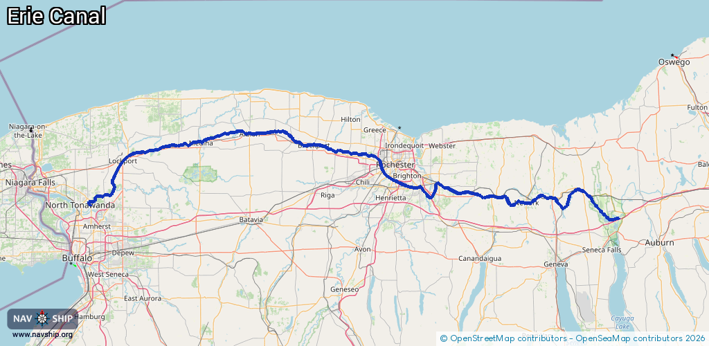
Route:
Please wait, loading route graphic...
Request waterway overview map with symbol legend here (Link).
Information about data associated with this body of water (17 available):
Data by OpenSeaMap (c) OSM contributors, www.openseamap.org
| # | Kind | Coordinates | Name | Information |
|---|---|---|---|---|
| 1 | Marina | 43.04766,-77.09302 | 2024-05-21T18:21:29Z | |
| 2 | Marina | 43.06655,-77.22913 | 2023-09-20T16:34:07Z | Port of Palmyra |
| 3 | Marina | 43.07648,-77.32289 | 2021-06-09T16:46:23Z | |
| 4 | Marina | 43.22113,-78.38555 | 2021-07-03T04:36:27Z | |
| 5 | Marina | 43.22114,-78.38527 | 2021-07-03T04:36:27Z | |
| 6 | Marina | 43.22114,-78.38546 | 2021-07-03T04:36:27Z | |
| 7 | Marina | 43.22115,-78.38507 | 2021-07-03T04:36:27Z | |
| 8 | Marina | 43.22114,-78.38536 | 2021-07-03T04:36:27Z | |
| 9 | Marina | 43.22115,-78.38517 | 2021-07-03T04:36:27Z | |
| 10 | Slipway | 43.03831,-78.82717 | small_craft_facility | 2013-05-12T15:22:13Z |
| 11 | Lock | 42.99878,-76.76179 | Lock 25 | |
| 12 | Lock | 43.05904,-76.8382 | Lock 26 | |
| 12 | Lock | 43.05904,-76.8382 | Lock 26 | |
| 12 | Lock | 43.05904,-76.8382 | Lock 26 | |
| 12 | Lock | 43.05904,-76.8382 | Lock 26 | |
| 13 | Lock | 43.06527,-77.24876 | Lock 29 | |
| 14 | Lock | 43.07338,-77.30195 | Lock 30 | |
| 15 | Lock | 43.0912,-77.54485 | Lock E32 | |
| 16 | Lock | 43.09596,-77.56944 | Lock 33 | |
| 17 | Lock | 43.11685,-77.63334 | East Guard Lock | |
| 17 | Lock | 43.11685,-77.63334 | East Guard Lock | |
| 17 | Lock | 43.11685,-77.63334 | East Guard Lock |