Waterway information

Kind:
Inland
Driving areas:
🌊 Atlantic Ocean🇬🇧 United Kingdom
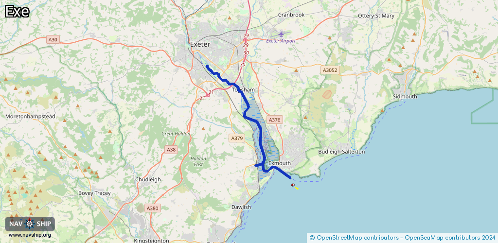
Length:
18.1 km¹
¹River kilometers or bank length recorded in NavShip, including river arms and harbor entrances.
Availability:
Completely recorded
Recent Update: 30.04.2025²
² This date indicates when an adjustment last took place in the course of the body of water
Recorded:
Locks: 0
Harbours / marinas: 3
Bridges: 0
Berths: 0
Slipways: 2
Fuelstations: 0
Route:
Please wait, loading route graphic...
Request waterway overview map with symbol legend here (Link).
Information about data associated with this body of water (5 available):
Data by OpenSeaMap (c) OSM contributors, www.openseamap.org
| # | Kind | Coordinates | Name | Information |
|---|---|---|---|---|
| 1 | Marina | 50.64803,-3.43274 | 2023-01-07T18:32:00Z | Lympstone Harbour https://www.lympstoneharbour.org.uk/ |
| 2 | Marina | 50.61761,-3.42348 | 2021-09-01T16:28:55Z | Exmouth Marina |
| 3 | Marina | 50.61766,-3.44824 | 2023-10-30T19:39:30Z | Cockwood Harbour |
| 4 | Slipway | 50.61095,-3.3991 | small_craft_facility | 2025-06-22T17:33:06Z |
| 5 | Slipway | 50.61082,-3.39959 | small_craft_facility | 2024-03-21T14:32:23Z |