Waterway information

Kind:
Inland
Driving areas:
🇩🇪 Germany
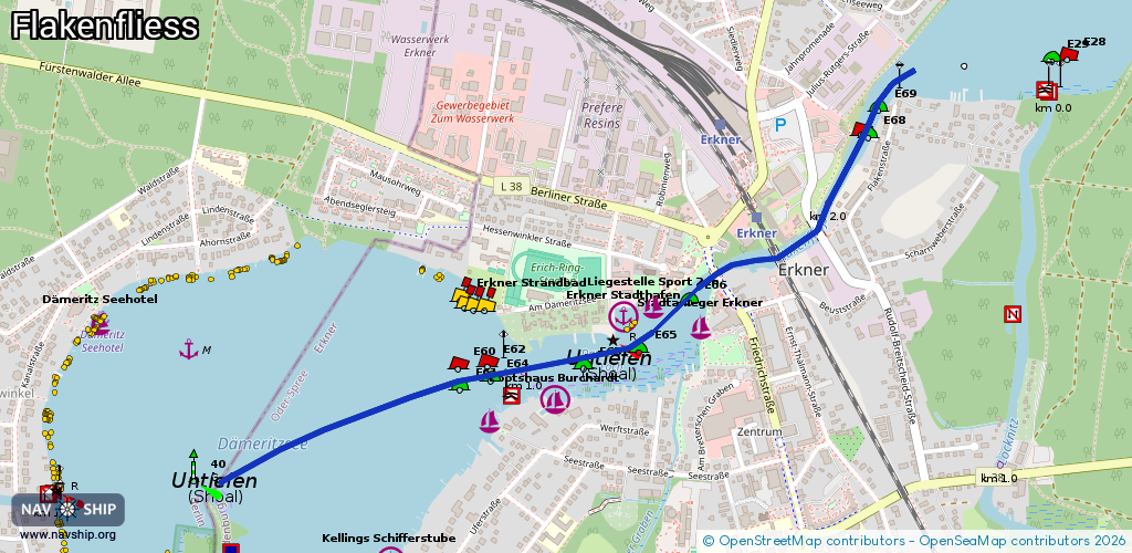
Length:
2.2 km¹
¹River kilometers or bank length recorded in NavShip, including river arms and harbor entrances.
Availability:
Completely recorded
Recent Update: 25.02.2026²
² This date indicates when an adjustment last took place in the course of the body of water
Recorded:
Locks: 0
Harbours / marinas: 5
Bridges: 3
Berths: 0
Slipways: 1
Fuelstations: 0
Route:
Please wait, loading route graphic...
Request waterway overview map with symbol legend here (Link).
Information about data associated with this body of water (9 available):
Data by OpenSeaMap (c) OSM contributors, www.openseamap.org
| # | Kind | Coordinates | Name | Information |
|---|---|---|---|---|
| 1 | Marina | 52.42245,13.74209 | 2013-04-02T08:48:16Z | Bootshaus Kimmritz +49 3362 3367 |
| 2 | Marina | 52.4229,13.74464 | 2013-04-01T23:44:10Z | Bootshaus Burchardt [email protected] +49 3362 3002 http://www.bootshaus-erkner.de |
| 3 | Marina | 52.42487,13.74729 | 2013-05-22T22:13:00Z | Erkner Stadthafen |
| 4 | Marina | 52.42516,13.74845 | 2015-09-22T17:34:56Z | Liegestelle Sport 24h |
| 5 | Marina | 52.42467,13.75029 | 2020-12-29T16:10:27Z | Stadtanleger Erkner |
| 6 | Bridge | 52.42586,13.75088 | 13.78 | Clearance height: 2012-10-21T09:32:42Z m Maximum passage width: 5.19 m Movable bridge (e.g. lifting bridge or drawbridge) fixed |
| 7 | Bridge | 52.42626,13.75324 | 22.25 | Clearance height: 2013-03-31T19:13:20Z m Maximum passage width: 5.21 m Movable bridge (e.g. lifting bridge or drawbridge) fixed |
| 8 | Bridge | 52.42696,13.75478 | 22 | Clearance height: 2012-10-21T09:32:42Z m Maximum passage width: 5.25 m Movable bridge (e.g. lifting bridge or drawbridge) fixed |
| 9 | Slipway | 52.42493,13.7424 | small_craft_facility | 2025-02-15T21:13:39Z |