Waterway information

Kind:
Inland
Driving areas:
🇩🇪 Germany
Length:
3 km¹
¹River kilometers or bank length recorded in NavShip, including river arms and harbor entrances.
Availability:
Completely recorded
Recent Update: 05.07.2024²
² This date indicates when an adjustment last took place in the course of the body of water
Recorded:
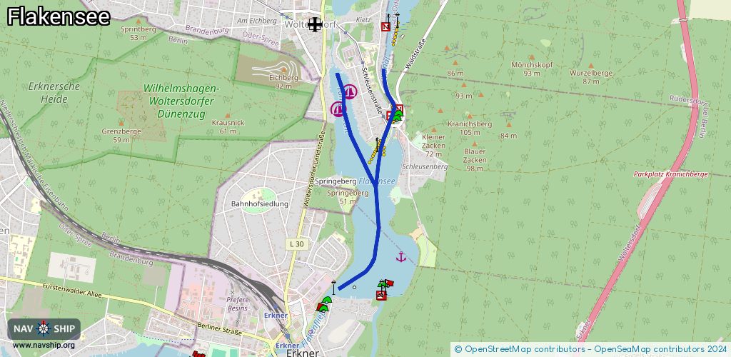
Locks: 1
Harbours / marinas: 2
Bridges: 2
Berths: 1
Slipways: 2
Fuelstations: 0
Route:
Please wait, loading route graphic...
Request waterway overview map with symbol legend here (Link).
Information about data associated with this body of water (8 available):
Data by OpenSeaMap (c) OSM contributors, www.openseamap.org
| # | Kind | Coordinates | Name | Information |
|---|---|---|---|---|
| 1 | Marina | 52.44514,13.7599 | 2013-04-02T08:48:10Z | MC Woltersdorf +49 30 65762930 |
| 2 | Marina | 52.44385,13.7586 | 2023-11-02T08:43:05Z | Segel Club Flakensee [email protected] +49 3362 5168 https://www.sc-flakensee.de/ |
| 3 | Bridge | 52.44274,13.76463 | Unknown | Clearance height: 2020-06-13T11:29:00Z m Movable bridge (e.g. lifting bridge or drawbridge) opening |
| 4 | Bridge | 52.44278,13.76467 | Unknown | Clearance height: 2013-04-01T06:38:41Z m Maximum passage width: 4.4 m Movable bridge (e.g. lifting bridge or drawbridge) fixed |
| 5 | Slipway | 52.44277,13.7651 | small_craft_facility | 2021-01-31T23:25:13Z Slippe Schleuse Woltersdorf |
| 6 | Slipway | 52.44202,13.765 | small_craft_facility | 2021-01-31T23:25:13Z Slippe Schleuse Woltersdorf |
| 7 | Berth | 52.43303,13.76612 | 2013-05-22T21:26:52Z | |
| 8 | Lock | 52.44311,13.76525 | Woltersdorf | +49 3362 503347 79 |