Waterway information

Kind:
Lake
Driving areas:
🇦🇹 Austria🇩🇪 Germany
Length:
21.1 km¹
¹River kilometers or bank length recorded in NavShip, including river arms and harbor entrances.
Availability:
Completely recorded
Recent Update: 10.01.2023²
² This date indicates when an adjustment last took place in the course of the body of water
Recorded:
Locks: 0
Harbours / marinas: 6
Bridges: 0
Berths: 0
Slipways: 1
Fuelstations: 0
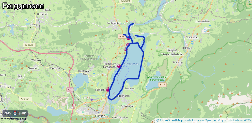
Route:
Please wait, loading route graphic...
Request waterway overview map with symbol legend here (Link).
Information about data associated with this body of water (7 available):
Data by OpenSeaMap (c) OSM contributors, www.openseamap.org
| # | Kind | Coordinates | Name | Information |
|---|---|---|---|---|
| 1 | Marina | 47.59144,10.71015 | 2022-07-28T21:48:09Z | Segelclub Füssen Forggensee |
| 2 | Marina | 47.59247,10.71036 | 2022-08-07T18:10:05Z | WSG Kaufbeuren |
| 3 | Marina | 47.6141,10.72541 | 2023-06-25T08:23:34Z | Bootshafen |
| 4 | Marina | 47.63014,10.73453 | 2021-02-09T15:56:45Z | Segelclub Dietringen |
| 5 | Marina | 47.63399,10.73779 | 2023-11-14T20:48:43Z | Forggensee Yachtschule [email protected] https://forggensee-yachtschule.de/ |
| 6 | Marina | 47.64053,10.73843 | 2024-02-05T19:13:46Z | Segelfreunde Marktoberdorf |
| 7 | Slipway | 47.6324,10.7349 | small_craft_facility | 2021-02-09T15:56:45Z |