Waterway information

Kind:
Inland
Driving areas:
🌊 Atlantic Ocean🇺🇸 United States of America
Length:
74.3 km¹
¹River kilometers or bank length recorded in NavShip, including river arms and harbor entrances.
Availability:
Completely recorded
Recent Update: 08.02.2024²
² This date indicates when an adjustment last took place in the course of the body of water
Recorded:
Locks: 0
Harbours / marinas: 13
Bridges: 0
Berths: 0
Slipways: 0
Fuelstations: 0
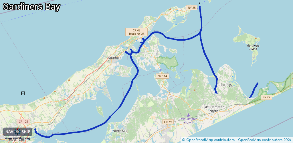
Route:
Please wait, loading route graphic...
Request waterway overview map with symbol legend here (Link).
Information about data associated with this body of water (13 available):
Data by OpenSeaMap (c) OSM contributors, www.openseamap.org
| # | Kind | Coordinates | Name | Information |
|---|---|---|---|---|
| 1 | Marina | 40.93647,-72.61707 | 2021-10-10T00:17:36Z | Lighthouse Marina |
| 2 | Marina | 41.0867,-72.35277 | 2021-12-02T13:54:21Z | Shelter Island Yacht Club |
| 3 | Marina | 41.10075,-72.36079 | 2023-11-12T17:13:54Z | Greenport Marina +1-631-477-2200 |
| 4 | Marina | 41.07743,-72.39983 | 2025-01-19T22:29:05Z | Hashamomuck Pond Waterway Access https://www.dec.ny.gov/ |
| 5 | Marina | 41.07623,-72.40286 | 2023-12-22T17:09:20Z | Port of Egypt Marine |
| 6 | Marina | 41.08044,-72.3873 | 2023-11-12T17:13:54Z | Brick Cove Marina |
| 7 | Marina | 41.02903,-72.18057 | 2021-08-10T18:30:32Z | |
| 8 | Marina | 41.0211,-72.17914 | 2021-08-10T18:30:32Z | |
| 9 | Marina | 41.01467,-72.18101 | 2021-08-10T18:30:32Z | |
| 10 | Marina | 41.00253,-72.18142 | 2023-01-29T06:04:11Z | Gardiner’s Bay https://www.seaincorp.com/ |
| 11 | Marina | 41.00101,-72.18259 | 2023-01-29T06:04:11Z | Three Mile Harbor Marina https://www.tmhmarina.com/, https://www.tmhmarina.com/, |
| 12 | Marina | 41.0005,-72.18292 | 2022-07-10T20:10:05Z | Three Mile Harbor Marina |
| 13 | Marina | 41.09281,-72.36475 | 2023-11-12T17:13:54Z |