Waterway information

Kind:
Inland
Driving areas:
🇺🇸 United States of America
Length:
9.3 km¹
¹River kilometers or bank length recorded in NavShip, including river arms and harbor entrances.
Availability:
Completely recorded
Recent Update: 05.12.2023²
² This date indicates when an adjustment last took place in the course of the body of water
Recorded:
Locks: 0
Harbours / marinas: 4
Bridges: 0
Berths: 0
Slipways: 0
Fuelstations: 2
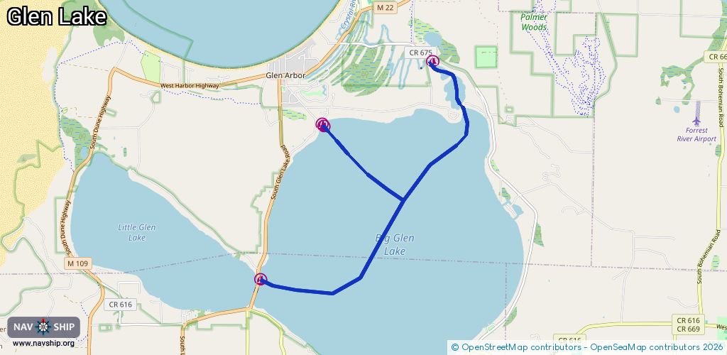
Route:
Please wait, loading route graphic...
Request waterway overview map with symbol legend here (Link).
Information about data associated with this body of water (6 available):
Data by OpenSeaMap (c) OSM contributors, www.openseamap.org
| # | Kind | Coordinates | Name | Information |
|---|---|---|---|---|
| 1 | Marina | 44.89973,-85.95323 | 2021-09-03T19:48:44Z | Crystal River Marina |
| 2 | Marina | 44.86277,-85.99499 | 2021-01-14T16:36:46Z | On The Narrows Marina +1-231-334-4891 https://www.narrows-marina.com/ |
| 3 | Marina | 44.88896,-85.97969 | 2021-01-12T13:54:12Z | Glen Craft Marina +1 231 334 4556 https://www.glencraftmarina.com/ |
| 4 | Marina | 44.88936,-85.98008 | 2021-02-18T21:23:17Z | Glen Lake Resort +1 231 334 4556 https://www.glenlakelodging.com/ |
| 5 | Fuel station | 44.86276,-85.99452 | 2023-01-18T19:18:51Z | |
| 6 | Fuel station | 44.88904,-85.97948 | 2024-01-26T13:42:46Z |