Waterway information

Kind:
Inland
Driving areas:
🇩🇪 Germany
Length:
5.1 km¹
¹River kilometers or bank length recorded in NavShip, including river arms and harbor entrances.
Availability:
Completely recorded
Recent Update: 05.07.2024²
² This date indicates when an adjustment last took place in the course of the body of water
Recorded:
Locks: 0
Harbours / marinas: 3
Bridges: 1
Berths: 3
Slipways: 0
Fuelstations: 0
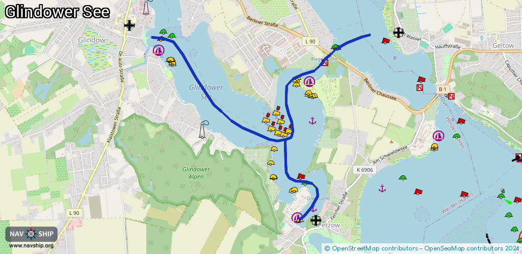
Route:
Please wait, loading route graphic...
Request waterway overview map with symbol legend here (Link).
Information about data associated with this body of water (7 available):
Data by OpenSeaMap (c) OSM contributors, www.openseamap.org
| # | Kind | Coordinates | Name | Information |
|---|---|---|---|---|
| 1 | Marina | 52.35994,12.94086 | 2012-12-20T12:37:48Z | Bootssteg Blütencamping Riegelspitze +49 3327 42397 www.campingplatz-riegelspitze.de/ |
| 2 | Marina | 52.36316,12.91527 | 2025-12-01T11:00:13Z | Porta Helena [email protected] +49 171 3722271, +49 171 4083666, +49 3327 46890 https://www.hogab.de/ |
| 3 | Marina | 52.34588,12.93883 | 2023-11-08T17:32:12Z | Yachthafen Porta Elisa [email protected] +49 171 4083666, +49 3327 40855 https://www.hogab.de/ferienpark-porta-elisa/yachthafen-porta-elisa.html |
| 4 | Bridge | 52.36276,12.94434 | 13.2 | Clearance height: 2023-09-18T07:05:38Z m Maximum passage width: 5.2 m Movable bridge (e.g. lifting bridge or drawbridge) fixed |
| 5 | Berth | 52.35588,12.94139 | 2023-08-14T16:42:12Z | |
| 6 | Berth | 52.36895,12.91538 | 2023-08-14T16:42:12Z | Sehr klares Wasser |
| 7 | Berth | 52.34685,12.94147 | 2012-08-20T22:18:11Z |