Waterway information

Kind:
Inland
Driving areas:
🇵🇱 Poland
Length:
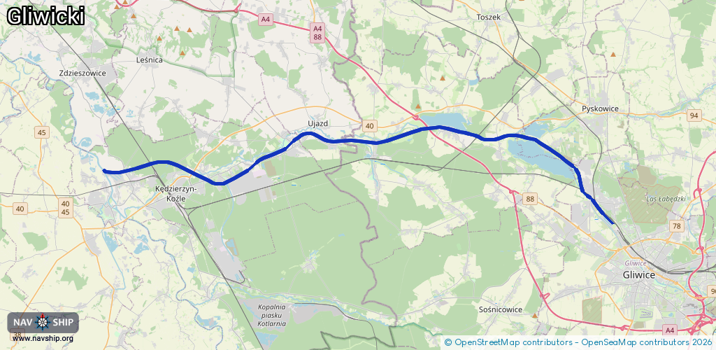
40.3 km¹
¹River kilometers or bank length recorded in NavShip, including river arms and harbor entrances.
Availability:
Completely recorded
Recent Update: 19.06.2023²
² This date indicates when an adjustment last took place in the course of the body of water
Recorded:
Locks: 6
Harbours / marinas: 6
Bridges: 0
Berths: 0
Slipways: 0
Fuelstations: 0
Route:
Please wait, loading route graphic...
Request waterway overview map with symbol legend here (Link).
Information about data associated with this body of water (12 available):
Data by OpenSeaMap (c) OSM contributors, www.openseamap.org
| # | Kind | Coordinates | Name | Information |
|---|---|---|---|---|
| 1 | Marina | 50.32805,18.63225 | 2019-03-21T15:20:41Z | Marina Gliwice https://marinagliwice.pl/ |
| 2 | Marina | 50.38022,18.56919 | 2023-02-21T08:31:37Z | Stowarzyszenie Sportów Wodnych Górnik |
| 3 | Marina | 50.38131,18.56 | 2023-02-21T08:31:37Z | Szkoła Żeglarska Maytur |
| 4 | Marina | 50.38127,18.5575 | 2024-05-03T15:36:57Z | Klub Wodny LOK „Garland” Gliwice https://kwgarland.pl/ |
| 5 | Marina | 50.3813,18.5555 | 2023-02-21T08:31:37Z | Turystyczny Klub Żeglarski Klar |
| 6 | Marina | 50.38195,18.55376 | 2024-01-09T20:23:03Z | Jacht Klub Dal |
| 7 | Lock | 50.33984,18.62117 | Unknown | |
| 8 | Lock | 50.38128,18.54409 | Unknown | |
| 9 | Lock | 50.37806,18.41717 | Unknown | |
| 10 | Lock | 50.3797,18.32977 | Unknown | |
| 11 | Lock | 50.35313,18.24225 | Unknown | |
| 12 | Lock | 50.36381,18.18693 | Unknown |