Waterway information

Kind:
Inland
Driving areas:
🇳🇱 Netherlands
Length:
7.4 km¹
¹River kilometers or bank length recorded in NavShip, including river arms and harbor entrances.
Availability:
Completely recorded
Recent Update: 21.08.2021²
² This date indicates when an adjustment last took place in the course of the body of water
Recorded:
Locks: 1
Harbours / marinas: 2
Bridges: 1
Berths: 0
Slipways: 3
Fuelstations: 1
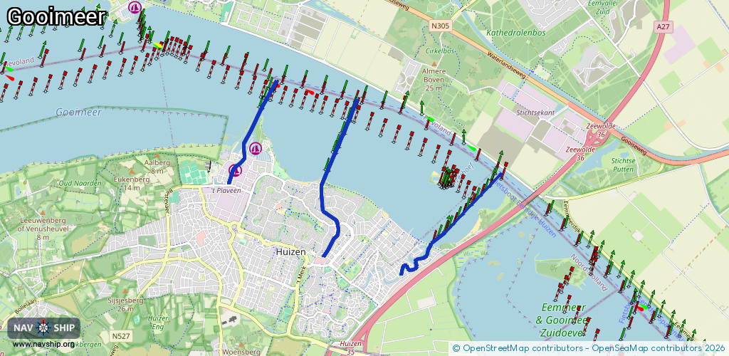
Route:
Please wait, loading route graphic...
Request waterway overview map with symbol legend here (Link).
Information about data associated with this body of water (8 available):
Data by OpenSeaMap (c) OSM contributors, www.openseamap.org
| # | Kind | Coordinates | Name | Information |
|---|---|---|---|---|
| 1 | Marina | 52.30788,5.24351 | 2024-09-16T08:53:39Z | Gemeentelijke Jachthaven Huizen +31 35 528 1222 https://www.huizen.nl/Toerisme_Vrije_tijd/Jachthavens/Gemeentelijke_haven |
| 2 | Marina | 52.31073,5.24887 | 2023-10-02T09:11:25Z | Jachthaven 't Huizerhoofd [email protected] +31 35 525 8622 https://www.jachthavenhuizen.nl/ |
| 3 | Bridge | 52.30568,5.26395 | 6 | Clearance height: 2022-06-06T08:53:11Z m Maximum passage width: 2.8 m Movable bridge (e.g. lifting bridge or drawbridge) bascule office hours, PH off |
| 4 | Slipway | 52.30997,5.24723 | small_craft_facility | 2020-11-21T17:09:03Z |
| 5 | Slipway | 52.30985,5.24778 | small_craft_facility | 2020-11-21T17:09:03Z |
| 6 | Slipway | 52.31014,5.2468 | small_craft_facility | 2020-11-21T17:09:03Z |
| 7 | Fuel station | 52.30989,5.24805 | 2023-10-02T09:11:25Z | |
| 8 | Lock | 52.29669,5.29019 | Sluis Blaricum | 020 608 79 98 10141 |