Waterway information

Kind:
Lake
Driving areas:
🇨🇭 Switzerland
Length:
13.6 km¹
¹River kilometers or bank length recorded in NavShip, including river arms and harbor entrances.
Availability:
Completely recorded
Recent Update: 10.08.2023²
² This date indicates when an adjustment last took place in the course of the body of water
Recorded:
Locks: 0
Harbours / marinas: 8
Bridges: 0
Berths: 1
Slipways: 1
Fuelstations: 0
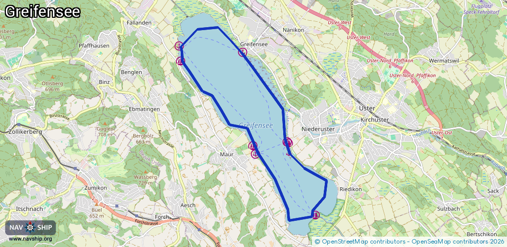
Route:
Please wait, loading route graphic...
Request waterway overview map with symbol legend here (Link).
Information about data associated with this body of water (10 available):
Data by OpenSeaMap (c) OSM contributors, www.openseamap.org
| # | Kind | Coordinates | Name | Information |
|---|---|---|---|---|
| 1 | Marina | 47.34227,8.67833 | 2015-03-27T00:14:53Z | Marina Maur |
| 2 | Marina | 47.34036,8.67919 | 2022-12-27T00:12:53Z | Maur (See) |
| 3 | Marina | 47.32598,8.69997 | 2022-12-27T00:12:53Z | Mönchaltorf (See) |
| 4 | Marina | 47.34323,8.69015 | 2024-06-18T11:23:47Z | Uster (See) |
| 5 | Marina | 47.34293,8.69058 | 2018-10-05T13:27:35Z | Marina Uster |
| 6 | Marina | 47.36433,8.67476 | 2020-12-31T13:23:14Z | Greifensee (See) |
| 7 | Marina | 47.36576,8.65271 | 2022-12-27T00:12:53Z | Fällanden (See) |
| 8 | Marina | 47.36233,8.65298 | 2022-12-27T00:12:53Z | |
| 9 | Slipway | 47.34089,8.67847 | small_craft_facility | 2023-03-18T16:18:28Z |
| 10 | Berth | 47.34078,8.69052 | 2015-03-27T00:21:36Z | Bojenfeld |