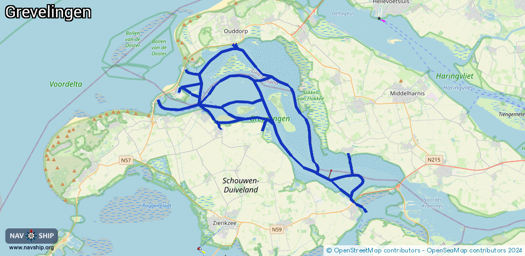
Waterway information

Kind:
Sea
Driving areas:
🇳🇱 Netherlands🌊 North Sea
Length:
94.8 km¹
¹River kilometers or bank length recorded in NavShip, including river arms and harbor entrances.
Availability:
Completely recorded
Recent Update: 24.02.2026²
² This date indicates when an adjustment last took place in the course of the body of water
Recorded:
Locks: 1
Harbours / marinas: 8
Bridges: 3
Berths: 0
Slipways: 11
Fuelstations: 1
Route:
Please wait, loading route graphic...
Request waterway overview map with symbol legend here (Link).
Information about data associated with this body of water (24 available):
Data by OpenSeaMap (c) OSM contributors, www.openseamap.org
| # | Kind | Coordinates | Name | Information |
|---|
| 1 | Marina | 51.79767,3.93428 | 2022-06-06T15:31:26Z | Ouddorpse haven
[email protected]
+31 187 683 020
https://www.wsvgoeree.nl/ |
| 2 | Marina | 51.72811,3.91444 | 2024-08-13T10:45:49Z | WV Brouwershaven
[email protected]
+31 111 691 330
https://www.wvbrouwershaven.nl/home |
| 3 | Marina | 51.74181,3.89253 | 2024-08-13T10:45:49Z | WSV Den Osse
[email protected]
+31 111 691 457
https://www.wsvdenosse.nl |
| 4 | Marina | 51.73908,3.84801 | 2025-05-16T19:55:24Z | Jachthaven Scharendijke
https://photos.app.goo.gl/qWAkGAEYxRBbVm878
[email protected]
+31 111 671 264
https://photos.app.goo.gl/qWAkGAEYxRBbVm878
[email protected]
+31 |
| 5 | Marina | 51.67019,4.08535 | 2013-11-25T08:14:27Z | Jachthaven Bruinisse |
| 6 | Marina | 51.66816,4.08857 | 2024-10-17T15:58:55Z | WSV BRU
https://www.wsvbru.nl/ |
| 7 | Marina | 51.75996,3.85859 | 2024-10-01T18:51:15Z | Marina Port Zélande
[email protected]
+31 111 671 920
https://www.mpz.nl |
| 8 | Marina | 51.73928,3.82686 | 2025-05-13T20:50:25Z | Haven West Repart |
| 9 | Bridge | 51.66736,4.09398 | 16 | Clearance height: 2020-03-11T13:15:04Z m
Maximum passage width: 6.45 m
Movable bridge (e.g. lifting bridge or drawbridge)
opening |
| 10 | Bridge | 51.66747,4.09377 | 16 | Clearance height: 2020-03-11T13:15:04Z m
Maximum passage width: 4.20 m
Movable bridge (e.g. lifting bridge or drawbridge)
opening |
| 11 | Bridge | 51.6663,4.09592 | 16 | Clearance height: 2020-03-11T13:15:04Z m
Maximum passage width: 5 m
Movable bridge (e.g. lifting bridge or drawbridge)
opening |
| 12 | Slipway | 51.79843,3.93761 | small_craft_facility | 2022-10-25T17:37:29Z |
| 13 | Slipway | 51.72805,3.91495 | small_craft_facility | 2022-10-25T19:17:49Z |
| 14 | Slipway | 51.74024,3.89254 | small_craft_facility | 2023-07-09T14:26:00Z |
| 15 | Slipway | 51.75225,3.83095 | small_craft_facility | 2023-07-14T22:27:38Z |
| 16 | Slipway | 51.67314,4.07551 | small_craft_facility | 2023-07-14T22:29:45Z |
| 17 | Slipway | 51.66824,4.0883 | small_craft_facility | 2024-10-17T15:58:55Z |
| 18 | Slipway | 51.77697,3.8675 | small_craft_facility | 2023-07-14T22:12:14Z |
| 19 | Slipway | 51.72639,3.97138 | small_craft_facility | 2022-10-25T17:20:12Z |
| 20 | Slipway | 51.72909,3.97143 | small_craft_facility | 2023-07-09T13:34:50Z |
| 21 | Slipway | 51.73097,3.97226 | small_craft_facility | 2023-07-09T13:25:35Z |
| 22 | Slipway | 51.67587,4.10566 | small_craft_facility | 2023-07-14T22:36:01Z |
| 23 | Fuel station | 51.67177,4.08366 | 2022-12-15T08:55:26Z | Gulf |
| 24 | Lock | 51.6668,4.09499 | Unknown | |