Waterway information

Kind:
Inland
Driving areas:
🇩🇪 Germany
Length:
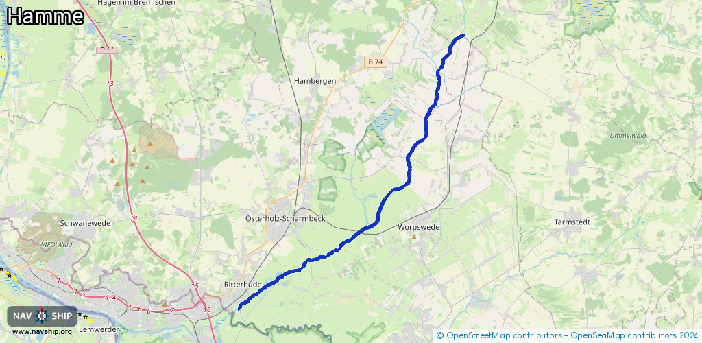
26.8 km¹
¹River kilometers or bank length recorded in NavShip, including river arms and harbor entrances.
Availability:
Completely recorded
Recent Update: 10.01.2026²
² This date indicates when an adjustment last took place in the course of the body of water
Recorded:
Locks: 2
Harbours / marinas: 3
Bridges: 1
Berths: 3
Slipways: 0
Fuelstations: 0
Route:
Please wait, loading route graphic...
Request waterway overview map with symbol legend here (Link).
Information about data associated with this body of water (9 available):
Data by OpenSeaMap (c) OSM contributors, www.openseamap.org
| # | Kind | Coordinates | Name | Information |
|---|---|---|---|---|
| 1 | Marina | 53.22776,8.8882 | 2023-11-09T00:25:17Z | Torfkähne Adolphsdorfer Torfschiffer https://www.torfschiffe.de/ |
| 2 | Marina | 53.22844,8.88853 | 2026-01-05T08:13:38Z | Worpsweder Torfschifffahrt [email protected] +49 4792 9897 575 https://www.worpsweder-torfschifffahrt.de |
| 3 | Marina | 53.18593,8.77052 | 2023-11-08T03:19:50Z | ESV Blau-Weiß Bremen - Ritterhude [email protected] +49 4298 3459 https://www.esv-blau-weiss-bremen.de/ |
| 4 | Bridge | 53.26772,8.9199 | Unknown | Clearance height: 2018-07-07T13:03:33Z m Maximum passage width: 2.18 m drawbridge |
| 5 | Berth | 53.21455,8.85448 | 2025-05-29T16:32:13Z | Melchers Hütte limited_period |
| 6 | Berth | 53.20378,8.81902 | 2014-04-22T11:58:29Z | Adolphsdorfer Torfschiffer !nur Torfschiffe! |
| 7 | Berth | 53.20383,8.81887 | 2014-04-22T11:58:29Z | small_craft |
| 8 | Lock | 53.30727,8.94774 | Unknown | |
| 9 | Lock | 53.26765,8.91983 | Unknown |