Waterway information

Kind:
Inland
Driving areas:
🇳🇱 Netherlands🌊 North Sea
Length:
3.5 km¹
¹River kilometers or bank length recorded in NavShip, including river arms and harbor entrances.
Availability:
Completely recorded
Recent Update: 16.01.2023²
² This date indicates when an adjustment last took place in the course of the body of water
Recorded:
Locks: 0
Harbours / marinas: 5
Bridges: 6
Berths: 0
Slipways: 0
Fuelstations: 1
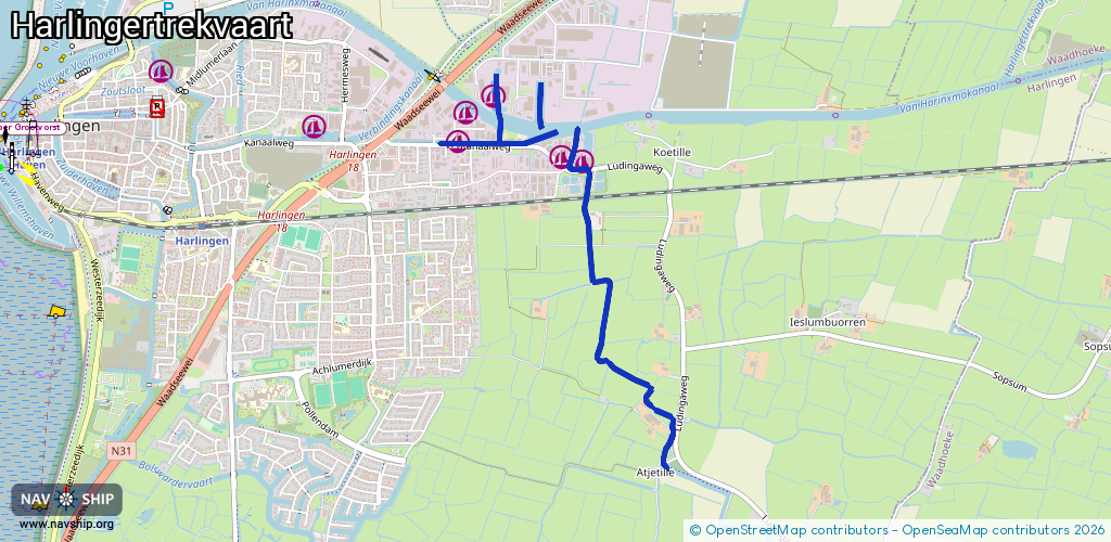
Route:
Please wait, loading route graphic...
Request waterway overview map with symbol legend here (Link).
Information about data associated with this body of water (12 available):
Data by OpenSeaMap (c) OSM contributors, www.openseamap.org
| # | Kind | Coordinates | Name | Information |
|---|---|---|---|---|
| 1 | Marina | 53.17442,5.44544 | 2024-06-09T15:49:42Z | Bijko jachtbouw [email protected] +31 517 415 116 https://www.bijko.nl/ |
| 2 | Marina | 53.17578,5.44607 | 2020-12-26T11:50:08Z | Jachtwerf Kosik [email protected] https://www.koningshaven.frl/ |
| 3 | Marina | 53.17642,5.44827 | 2024-06-17T17:31:56Z | Jachthaven North-Line Yachts [email protected] +31 517 391 054 https://www.north-line.nl/ |
| 4 | Marina | 53.17341,5.4551 | 2024-10-11T11:50:00Z | Jachtwerf Ouwehand https://www.jachtwerfouwehand.nl/ |
| 5 | Marina | 53.17365,5.45365 | 2024-10-11T11:50:00Z | Multiship Harlingen |
| 6 | Bridge | 53.15903,5.46178 | Unknown | Clearance height: 2024-06-22T17:54:15Z m Movable bridge (e.g. lifting bridge or drawbridge) fixed |
| 7 | Bridge | 53.16949,5.45586 | 5.5 | Clearance height: 2021-12-21T19:06:11Z m |
| 8 | Bridge | 53.17174,5.45552 | 3.6 | Clearance height: 2021-12-21T19:06:11Z m |
| 9 | Bridge | 53.17248,5.45574 | Unknown | Clearance height: 2021-12-21T19:06:11Z m |
| 10 | Bridge | 53.17307,5.45576 | Unknown | Clearance height: 2021-12-21T19:06:11Z m |
| 11 | Bridge | 53.17313,5.4545 | Unknown | Clearance height: 2021-12-21T19:06:11Z m |
| 12 | Fuel station | 53.17458,5.45266 | 2020-09-24T14:44:54Z |