Waterway information

Kind:
Inland
Driving areas:
🇳🇱 Netherlands🌊 North Sea
Length:
6.5 km¹
¹River kilometers or bank length recorded in NavShip, including river arms and harbor entrances.
Availability:
Completely recorded
Recent Update: 31.10.2022²
² This date indicates when an adjustment last took place in the course of the body of water
Recorded:
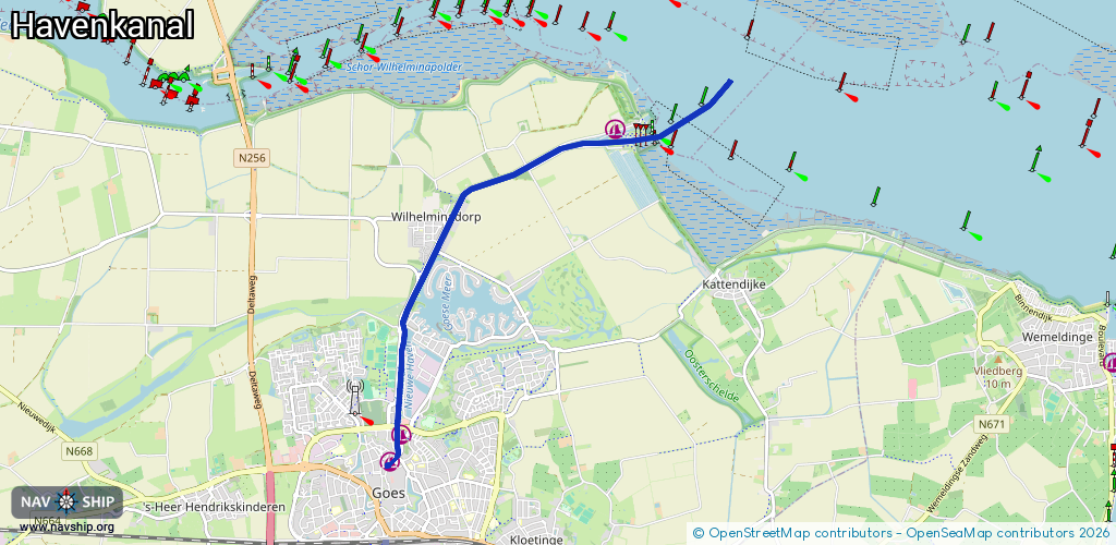
Locks: 1
Harbours / marinas: 3
Bridges: 3
Berths: 0
Slipways: 1
Fuelstations: 0
Route:
Please wait, loading route graphic...
Request waterway overview map with symbol legend here (Link).
Information about data associated with this body of water (8 available):
Data by OpenSeaMap (c) OSM contributors, www.openseamap.org
| # | Kind | Coordinates | Name | Information |
|---|---|---|---|---|
| 1 | Marina | 51.53842,3.92578 | 2023-11-29T13:50:34Z | jachthaven Hansa [email protected] +31 113 223 944 https://www.hansawatersport.nl/ |
| 2 | Marina | 51.50875,3.89177 | 2023-05-30T12:27:01Z | Jachthaven De Werf [email protected] +31 113 216 372 https://jachthavendewerf.nl/informatie-voor-passanten/ |
| 3 | Marina | 51.50605,3.88989 | 2023-05-31T06:20:26Z | Stadshaven monument = Gemetselde kademuren aan Grote Kade, Bierkade, Turfkade en Kleine Kade. +31 6 54300983 https://stadshavengoes.nl https://stadshavengoes.nl |
| 4 | Bridge | 51.52973,3.89947 | 10 | Clearance height: 2024-10-29T14:17:29Z m Maximum passage width: 1 m Movable bridge (e.g. lifting bridge or drawbridge) drawbridge |
| 5 | Bridge | 51.50957,3.89109 | 8.6 | Clearance height: 2013-12-13T15:09:30Z m Maximum passage width: 1.8 m Movable bridge (e.g. lifting bridge or drawbridge) opening |
| 6 | Bridge | 51.50667,3.89102 | 6.25 | Clearance height: 2024-06-10T16:57:51Z m Maximum passage width: 2.3 m Movable bridge (e.g. lifting bridge or drawbridge) opening |
| 7 | Slipway | 51.53878,3.92754 | small_craft_facility | 2023-07-14T23:13:10Z |
| 8 | Lock | 51.53745,3.92531 | Unknown |