Waterway information

Kind:
Inland
Driving areas:
🇳🇱 Netherlands
Length:
8 km¹
¹River kilometers or bank length recorded in NavShip, including river arms and harbor entrances.
Availability:
Completely recorded
Recent Update: 07.08.2025²
² This date indicates when an adjustment last took place in the course of the body of water
Recorded:
Locks: 1
Harbours / marinas: 2
Bridges: 2
Berths: 0
Slipways: 1
Fuelstations: 0
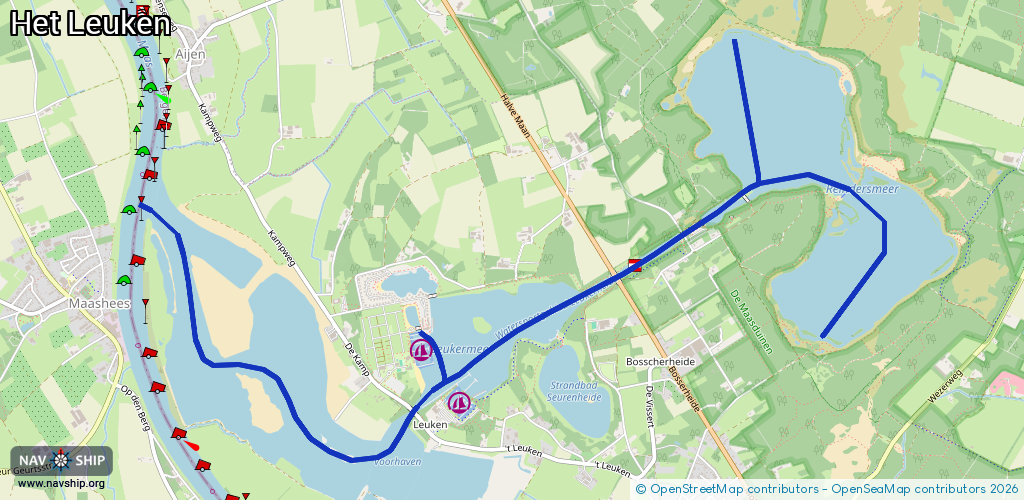
Route:
Please wait, loading route graphic...
Request waterway overview map with symbol legend here (Link).
Information about data associated with this body of water (6 available):
Data by OpenSeaMap (c) OSM contributors, www.openseamap.org
| # | Kind | Coordinates | Name | Information |
|---|---|---|---|---|
| 1 | Marina | 51.56561,6.06564 | 2023-05-30T19:34:04Z | Jachthaven 't Leuken [email protected] +31 478 501 758 https://www.valckxwatersport.nl |
| 2 | Marina | 51.56817,6.06212 | 2024-11-02T11:59:41Z | Jachthaven Leukermeer [email protected] +31 478 502 444 https://www.leukermeer.nl/jachthaven |
| 3 | Bridge | 51.57217,6.07925 | 17 | Clearance height: 2013-02-20T18:07:55Z m Maximum passage width: 8.77 m Movable bridge (e.g. lifting bridge or drawbridge) fixed |
| 4 | Bridge | 51.565,6.06181 | 13 | Clearance height: 2013-02-20T18:07:55Z m Maximum passage width: 8.65 m Movable bridge (e.g. lifting bridge or drawbridge) fixed |
| 5 | Slipway | 51.56552,6.06443 | Unknown | 2021-09-05T19:24:47Z |
| 6 | Lock | 51.57476,6.08575 | Oude Sluis |