Waterway information

Kind:
Sea
Driving areas:
🇩🇪 Germany🌊 North Sea
Length:
6.7 km¹
¹River kilometers or bank length recorded in NavShip, including river arms and harbor entrances.
Availability:
Completely recorded
Recent Update: 09.04.2025²
² This date indicates when an adjustment last took place in the course of the body of water
Recorded:
Locks: 1
Harbours / marinas: 6
Bridges: 0
Berths: 0
Slipways: 4
Fuelstations: 0
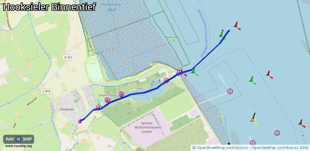
Route:
Please wait, loading route graphic...
Request waterway overview map with symbol legend here (Link).
Information about data associated with this body of water (11 available):
Data by OpenSeaMap (c) OSM contributors, www.openseamap.org
| # | Kind | Coordinates | Name | Information |
|---|---|---|---|---|
| 1 | Marina | 53.62708,8.02881 | 2023-09-12T16:49:55Z | Alter Hafen Hooksiel |
| 2 | Marina | 53.63166,8.03944 | 2023-09-25T22:23:28Z | WSV Hooksiel |
| 3 | Marina | 53.63388,8.04397 | 2024-02-22T08:06:37Z | Marina Hooksiel [email protected] +49 4425 958012 https://www.wangerland.de/poi/marina-hooksiel |
| 4 | Marina | 53.63604,8.052 | 2023-04-10T20:50:57Z | Yachthafen des Wilhelmshavener Segelclub https://www.segelnimwsc.de/ |
| 5 | Marina | 53.64068,8.07766 | 2023-04-10T16:12:21Z | Werft Hooksiel [email protected] +49 4425 95850 https://www.werfthooksiel.de/ |
| 6 | Marina | 53.64319,8.08524 | 2023-04-10T20:50:57Z | Aussenhafen Hooksiel |
| 7 | Slipway | 53.63199,8.03985 | Unknown | 2016-09-20T16:11:54Z |
| 8 | Slipway | 53.63563,8.04446 | small_craft_facility | 2023-04-10T00:11:59Z Slip Hooksiel |
| 9 | Slipway | 53.64074,8.0774 | small_craft_facility | 2017-07-07T11:00:35Z |
| 10 | Slipway | 53.64146,8.08273 | small_craft_facility | 2017-07-30T10:03:57Z |
| 11 | Lock | 53.64171,8.08143 | Schleuse Hooksiel | 04425430 |