Waterway information

Kind:
Inland
Driving areas:
🌊 Atlantic Ocean🇺🇸 United States of America
Length:
6 km¹
¹River kilometers or bank length recorded in NavShip, including river arms and harbor entrances.
Availability:
Completely recorded
Recent Update: 06.02.2024²
² This date indicates when an adjustment last took place in the course of the body of water
Recorded:
Locks: 0
Harbours / marinas: 14
Bridges: 0
Berths: 0
Slipways: 0
Fuelstations: 0
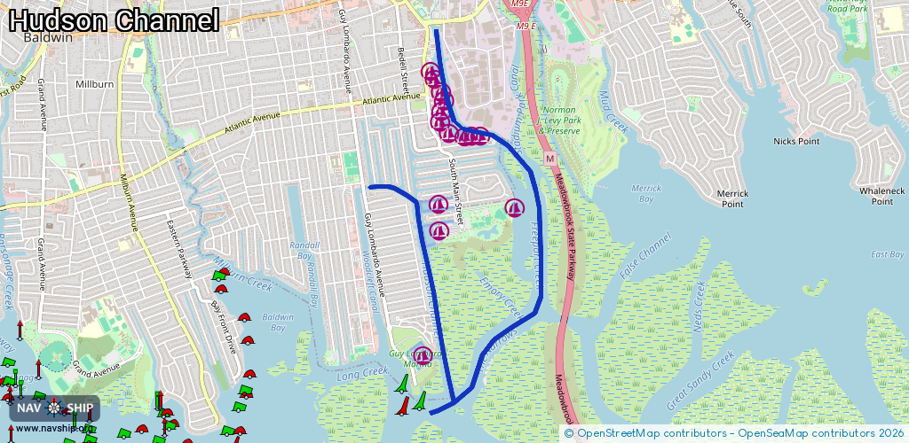
Route:
Please wait, loading route graphic...
Request waterway overview map with symbol legend here (Link).
Information about data associated with this body of water (14 available):
Data by OpenSeaMap (c) OSM contributors, www.openseamap.org
| # | Kind | Coordinates | Name | Information |
|---|---|---|---|---|
| 1 | Marina | 40.63833,-73.57501 | 2020-05-19T21:33:26Z | |
| 2 | Marina | 40.6365,-73.57404 | 2022-06-16T00:40:14Z | |
| 3 | Marina | 40.62734,-73.57589 | 2020-05-19T21:33:26Z | Guy Lombardo Marina |
| 4 | Marina | 40.64759,-73.57525 | 2020-05-19T21:33:26Z | Baldwin Harbor Yacht Club |
| 5 | Marina | 40.64819,-73.57552 | 2020-05-19T21:33:26Z | |
| 6 | Marina | 40.64605,-73.57421 | 2020-05-19T21:33:26Z | Midway Marina |
| 7 | Marina | 40.64643,-73.57456 | 2020-05-19T21:33:26Z | A C Marine Services |
| 8 | Marina | 40.64522,-73.57451 | 2022-07-29T22:14:40Z | |
| 9 | Marina | 40.64361,-73.57377 | 2020-05-19T21:33:26Z | Al Grovers High & Dry Marina |
| 10 | Marina | 40.64448,-73.57475 | 2022-07-29T22:14:40Z | |
| 11 | Marina | 40.6433,-73.57221 | 2020-05-19T21:33:26Z | Outboard Service Corp. |
| 12 | Marina | 40.64343,-73.57049 | 2020-05-19T21:33:26Z | Saltair Marina |
| 13 | Marina | 40.64348,-73.57148 | 2020-05-19T21:33:26Z | Rick's Marine |
| 14 | Marina | 40.6381,-73.56724 | 2020-05-19T21:33:26Z |